IMAGES TAKEN NEAR TO
Daylily Close, NP16 5UU
Introduction
This page details the photographs taken nearby to Daylily Close, NP16 5UU by members of the Geograph project.
The Geograph project started in 2005 with the aim of publishing, organising and preserving representative images for every square kilometre of Great Britain, Ireland and the Isle of Man.

There are currently over 7.5m images from over14,400 individuals and you can help contribute to the project by visiting https://www.geograph.org.uk
Image Map
Images are licensed for reuse under creativecommons.org/licenses/by-sa/2.0
Notes
- Clicking on the map will re-center to the selected point.
- The higher the marker number, the further away the image location is from the centre of the postcode.
Image Listing (251 Images Found)
Images are licensed for reuse under creativecommons.org/licenses/by-sa/2.0
Image
Details
Distance
1
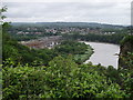
The river Wye
Looking down on the Wye from bulwark. In the distance is the village of Sedbury in Gloucestershire and to the left on this side of the river is the Mabey bridge factory site.
Image: © Mark Hobbs
Taken: 20 Jun 2011
0.01 miles
2

Roofless former Mabey Bridge site in Chepstow
Viewed in July 2016. The derelict site was Mabey Bridge's turbine tower building plant which closed in September 2015 with the loss of 120 jobs.
Image: © Jaggery
Taken: 7 Jul 2016
0.02 miles
3
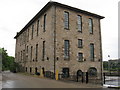
Chepstow Shipyard
New build of 347 dwellings on the old shipyard, Buffers Wharf.
The large building at the right of centre was a steam powered flour mill in 1851.
Image: © Peter Randall-Cook
Taken: 4 Nov 2021
0.04 miles
4

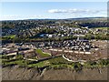
New housing being built on old shipyard site in Chepstow
This view was possible because a temporary footbridge is in place Image allowing for the removal for repair of the old footbridge. The houses are part of a major development of what was the old shipyard, and more recently the site of the Mabey Bridge works.
Image: © Ruth Sharville
Taken: 6 Feb 2021
0.06 miles
5

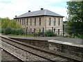
Footbridge, Chepstow Station
Footbridge over the railway lines at Chepstow Station.
Image: © Philip Halling
Taken: 10 May 2008
0.07 miles
6
![Chepstow houses [69]](https://s2.geograph.org.uk/geophotos/07/35/95/7359514_2c199f1c_120x120.jpg)
Chepstow houses [69]
The Brunel Quarter development is of 345 houses on an area of approximately 50 acres (20 hectares) and comprises the former Mabey Bridge engineering works, including many industrial buildings, the former shipyard made up of four slipways, the former Beaufort Quarry, Brunel House and an industrial area at the far north of the site. The site is between the railway lines and the River Wye.
Chepstow, the most easterly town in Wales, is located on the tidal River Wye, some 3 miles above its confluence with the River Severn. There is evidence of continuous human occupation from the Mesolithic period. The town grew in importance when the Normans erected a castle at what was the lowest bridging point of the River Wye. The town flourished as a port, being exempt from English taxation, and it mainly traded in timber and bark from the Wye Valley. The town became an important centre for tourism from the late eighteenth century.
Image: © Michael Dibb
Taken: 3 Sep 2022
0.07 miles
7
Lineside building, Chepstow
Viewed from the northern edge of Chepstow railway station. The building is used by Forest Sand, in the industrial area adjacent to Buffer Wharf at the far end of Mill Lane.
Image: © Jaggery
Taken: 8 Sep 2010
0.07 miles
8
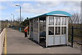
New shelter Chepstow Station
The man in the orange jacket was doing the final sweep up, as the barricades had just been removed, on the morning this new shelter was opened for use.
Image: © Ruth Sharville
Taken: 24 Mar 2009
0.07 miles
9

Track from Mill Lane towards Chepstow railway station
Viewed through locked gates, the track is for authorised staff and vehicles only.
Image: © Jaggery
Taken: 7 Jul 2016
0.08 miles