IMAGES TAKEN NEAR TO
Burnt Barn Road, CHEPSTOW, NP16 5UP
Introduction
This page details the photographs taken nearby to Burnt Barn Road, NP16 5UP by members of the Geograph project.
The Geograph project started in 2005 with the aim of publishing, organising and preserving representative images for every square kilometre of Great Britain, Ireland and the Isle of Man.

There are currently over 7.5m images from over14,400 individuals and you can help contribute to the project by visiting https://www.geograph.org.uk
Image Map
Images are licensed for reuse under creativecommons.org/licenses/by-sa/2.0
Notes
- Clicking on the map will re-center to the selected point.
- The higher the marker number, the further away the image location is from the centre of the postcode.
Image Listing (99 Images Found)
Images are licensed for reuse under creativecommons.org/licenses/by-sa/2.0
Image
Details
Distance
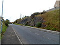
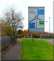
1
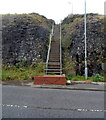
Steps up to Burnt Barn Road, Chepstow
Viewed across an unnamed access road http://www.geograph.org.uk/photo/3341217 to M48 motorway junction 2.
Image: © Jaggery
Taken: 13 Nov 2012
0.03 miles
2
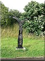
Millennium milepost on NCN4 west of the Severn Bridge
The directions read Chepstow 2M Usk 15M (left). Bristol 17M, Gloucester 38M (right).
See Image for a photo of the setting.
Image: © Colin Bell
Taken: 17 Jul 2009
0.06 miles
3
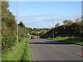
Conway Drive
Road from Junction 2, M48 Motorway towards Chepstow.
Image: © JThomas
Taken: 15 Oct 2019
0.06 miles
4
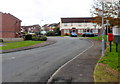
Lord Eldon Drive, Bulwark, Chepstow
A view looking SW from the Thornwell Road end.
Image: © Jaggery
Taken: 13 Nov 2012
0.06 miles
5
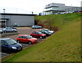
Chepstow Ford, Bulwark, Chepstow
Viewed from a grassy bank at the edge of a Homebase store. At the top of the bank,
Chepstow Ford is located in Beaufort Park Way, near M48 motorway junction 2.
Image: © Jaggery
Taken: 13 Nov 2012
0.07 miles
6
Location of millennium milepost on NCN 4 near the Severn Bridge
The cycle path (behind the fence) climbs above the A466 as it enters Wales. There is a black milepost at the left of the picture but it is camouflaged!
See alsoImage
(This photo is taken from directly in front of the Welcome to Wales sign for motorists. Cyclists don't get one.)
Image: © Colin Bell
Taken: 17 Jul 2009
0.07 miles
7
Unnamed access road to M48 motorway junction 2, Chepstow
The Thornwell Road roundabout is behind the camera. The M48 motorway is out of shot ahead.
On the right, behind a lamp post in the middle distance, steps http://www.geograph.org.uk/photo/3341210 lead up to Burnt Barn Road.
Image: © Jaggery
Taken: 13 Nov 2012
0.07 miles
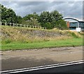
8
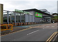
Homebase, Chepstow
The Chepstow DiY store & garden centre is in Beaufort Park, Thornwell, near M48 motorway junction 2.
Image: © Jaggery
Taken: 13 Nov 2012
0.07 miles
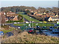
9
Approaching M48 junction 2 from Bulwark, Chepstow
The large Newhouse (roundabout) sign shows which slip road
to take ahead for the M48 westbound or eastbound.
Image: © Jaggery
Taken: 13 Nov 2012
0.08 miles
10
Lower thornwell
A view of lower thornwell, bulwark, Chepstow looking towards Warren slade woods in the distance.
Image: © Mark Hobbs
Taken: 4 Jan 2010
0.08 miles