IMAGES TAKEN NEAR TO
The Hawthornes, USK, NP15 2HF
Introduction
This page details the photographs taken nearby to The Hawthornes, NP15 2HF by members of the Geograph project.
The Geograph project started in 2005 with the aim of publishing, organising and preserving representative images for every square kilometre of Great Britain, Ireland and the Isle of Man.

There are currently over 7.5m images from over14,400 individuals and you can help contribute to the project by visiting https://www.geograph.org.uk
Image Map
Images are licensed for reuse under creativecommons.org/licenses/by-sa/2.0
Notes
- Clicking on the map will re-center to the selected point.
- The higher the marker number, the further away the image location is from the centre of the postcode.
Image Listing (286 Images Found)
Images are licensed for reuse under creativecommons.org/licenses/by-sa/2.0
Image
Details
Distance
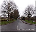
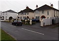
1
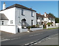
Chepstow Road houses, Raglan
Houses on the west side of the road, viewed from opposite the turning into Fayre Oaks. http://www.geograph.org.uk/photo/2086850
Image: © Jaggery
Taken: 26 Sep 2010
0.02 miles
2
Elm Cottages, Raglan
Located on Chepstow Road.
Image: © Jaggery
Taken: 26 Sep 2010
0.02 miles
3
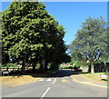
West along Fayre Oaks/Derwen Deg, Raglan
The tree-lined road named Fayre Oaks (Derwen Deg in Welsh) https://www.geograph.org.uk/photo/5833960 viewed across Chepstow Road.
Image: © Jaggery
Taken: 8 Jul 2018
0.03 miles
4
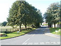
Fayre Oaks, Raglan
Viewed across Chepstow Road. A short tree-lined section of road leads to houses on Fayre Oaks.
The street signs also show the Welsh name of the street, Derwen Deg.
http://www.geograph.org.uk/photo/3803638 to a view in winter.
Image: © Jaggery
Taken: 26 Sep 2010
0.05 miles
5
Winter view along Fayre Oaks, Raglan
Viewed across Chepstow Road. http://www.geograph.org.uk/photo/2086850 to a leafy view.
Image: © Jaggery
Taken: 5 Jan 2014
0.06 miles
6
Under scaffolding, Chepstow Road, Raglan
A detached house on the west side of Chepstow Road is under scaffolding in early July 2018.
Image: © Jaggery
Taken: 8 Jul 2018
0.07 miles
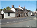
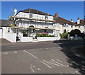
7
Houses on the west side of Chepstow Road, Raglan
Two semi-detached houses in the middle, a detached house on the left and right.
Image: © Jaggery
Taken: 8 Jul 2018
0.07 miles
8
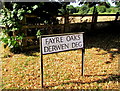
Bilingual name sign on a Raglan corner
The sign on the left here https://www.geograph.org.uk/photo/5833947 shows that Fayre Oaks is Derwen Deg in Welsh.
Image: © Jaggery
Taken: 8 Jul 2018
0.07 miles
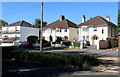
9
Chepstow Road houses, Raglan
The house on the left is about a century older than its neighbours. It dates from before 1841, the year in which it was shown on a tithe map. Now named Dean House, it used to be Dean Cottage and also The Manse when it was the residence of Baptist ministers from 1900-1940.
Image: © Jaggery
Taken: 5 Jan 2014
0.07 miles
10
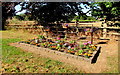
Chepstow Road flowerbed, Raglan
Near the corner of Fayre Oaks viewed in early July 2018.
Image: © Jaggery
Taken: 8 Jul 2018
0.07 miles