IMAGES TAKEN NEAR TO
High Street, USK, NP15 2EA
Introduction
This page details the photographs taken nearby to High Street, NP15 2EA by members of the Geograph project.
The Geograph project started in 2005 with the aim of publishing, organising and preserving representative images for every square kilometre of Great Britain, Ireland and the Isle of Man.

There are currently over 7.5m images from over14,400 individuals and you can help contribute to the project by visiting https://www.geograph.org.uk
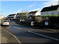
Image Map
Images are licensed for reuse under creativecommons.org/licenses/by-sa/2.0
Notes
- Clicking on the map will re-center to the selected point.
- The higher the marker number, the further away the image location is from the centre of the postcode.
Image Listing (279 Images Found)
Images are licensed for reuse under creativecommons.org/licenses/by-sa/2.0
Image
Details
Distance
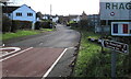
1
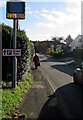
Free parking direction sign, High Street, Raglan, Monmouthshire
The sign shows that Free in this context is Di-dâl (without payment) in Welsh. The Thank You display is for the car travelling within the speed limit.
Image: © Jaggery
Taken: 22 Nov 2020
0.03 miles
2
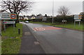
NW boundary of Raglan
The National Speed Limit on the A40 behind the camera reduces to 30mph ahead along High Street.
The boundary sign shows that Raglan is twinned with Parcé sur Sarthe in France.
Image: © Jaggery
Taken: 5 Jan 2014
0.04 miles
3
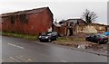
Derelict High Street site in Raglan
The demolition of a barn-like single-storey building has not improved the appearance of this site...
Image: © Jaggery
Taken: 5 Jan 2014
0.04 miles
4
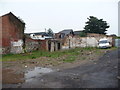
Old building remnants in Raglan
Some demolition work has gone on here recently, opening up a possible development plot. I can't recall what was here before.
Image: © Jeremy Bolwell
Taken: 12 Aug 2012
0.04 miles
5
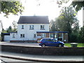
Raglan Police Station
Located on the corner of High Street and Fairfax View.
Image: © Jaggery
Taken: 26 Sep 2010
0.04 miles
6
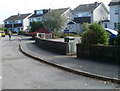
Fairfax View, Raglan
Houses on the east side of the road, viewed from near the corner of High Street.
Image: © Jaggery
Taken: 26 Sep 2010
0.04 miles
7
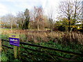
Greenfield site sold at auction, Raglan, Monmouthshire
Set back from the corner of High Street and the A40 viewed in November 2020.
Image: © Jaggery
Taken: 22 Nov 2020
0.04 miles
8

Northern boundary of Raglan, Monmouthshire
Looking south along High Street from near the A40 junction.
Raglan (Rhaglan in Welsh) is twinned with Parcé-Sur-Sarthe (France).
Image: © Jaggery
Taken: 22 Nov 2020
0.05 miles
9
The Beaufort Coaching Inn direction sign, High Street, Raglan, Monmouthshire
Located on the right here. https://www.geograph.org.uk/photo/6720350
Image: © Jaggery
Taken: 22 Nov 2020
0.05 miles
10
Fairfax View houses, Raglan
From High Street, Fairfax View leads to Beaufort Gardens and Somerset Drive.
Image: © Jaggery
Taken: 22 Nov 2020
0.05 miles