IMAGES TAKEN NEAR TO
Monkswood, USK, NP15 1PX
Introduction
This page details the photographs taken nearby to NP15 1PX by members of the Geograph project.
The Geograph project started in 2005 with the aim of publishing, organising and preserving representative images for every square kilometre of Great Britain, Ireland and the Isle of Man.

There are currently over 7.5m images from over14,400 individuals and you can help contribute to the project by visiting https://www.geograph.org.uk
Image Map
Images are licensed for reuse under creativecommons.org/licenses/by-sa/2.0
Notes
- Clicking on the map will re-center to the selected point.
- The higher the marker number, the further away the image location is from the centre of the postcode.
Image Listing (38 Images Found)
Images are licensed for reuse under creativecommons.org/licenses/by-sa/2.0
Image
Details
Distance
1

Public footpath to the A472
Running south from the western end of Estavarney Lane.
Image: © Christine Johnstone
Taken: 13 Sep 2013
0.09 miles
2
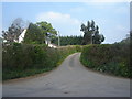
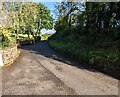
Junction of single track roads.
This view is typical of the network of single track roads with VERY few passing places. You feel as if you're miles from an A road, yet the A472 is barely 0.5km away.
Image: © Ruth Sharville
Taken: 20 Apr 2007
0.10 miles
3
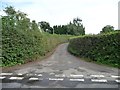
Estavarney Lane
At the junction with Cefn Mawr Lane, which is a 66 metre spot height.
Image: © Christine Johnstone
Taken: 13 Sep 2013
0.11 miles
4

Cefn Mawr Lane
Heading north-west towards Penpedairheol crossroads.
Image: © Christine Johnstone
Taken: 13 Sep 2013
0.11 miles
5
Barn alongside the A472, Monkswood
Viewed from near the junction for West Road and Beaufort Crescent.
Image: © Jaggery
Taken: 26 Oct 2012
0.19 miles
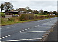
6
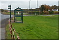
Bus shelter in a hedge, Monkswood
Located on the north side of the A472, facing a T junction. The shelter is on bus route 63 from Cwmbran to Chepstow via Pontypool, Little Mill and Shirenewton. I wasn't certain that this shelter is still in use, because the usual bus stop road markings, as here http://www.geograph.org.uk/photo/3196303 are absent.
Image: © Jaggery
Taken: 26 Oct 2012
0.19 miles
7
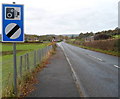
Speed camera warning, Monkswood
The combined National Speed Limit and speed camera sign is alongside the A472
on the approach to the junction for houses in West Road and Beaufort Crescent.
Image: © Jaggery
Taken: 26 Oct 2012
0.19 miles
8
Cefn Mawr Lane NW of St Matthew's churchyard, Monkswood
Ahead for Penpedairheol. Behind the camera for the A472, the main road through Monkswood.
Image: © Jaggery
Taken: 3 Oct 2021
0.20 miles
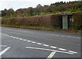
9
Beaufort Crescent bus stop and shelter, Monkswood
The bus stop sign shows Beaufort Crescent, which is about 120 metres from the sign's location on the south side of the A472. The bus stop is on route 63 from Chepstow to Cwmbran via Shirenewton, Little Mill and Pontypool.
Image: © Jaggery
Taken: 26 Oct 2012
0.20 miles
10
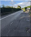
West along the A472, Monkswood
Ahead for Little Mill. The double white lines indicate no overtaking.
Image: © Jaggery
Taken: 3 Oct 2021
0.20 miles