IMAGES TAKEN NEAR TO
Bournville Road, ABERTILLERY, NP13 3ES
Introduction
This page details the photographs taken nearby to Bournville Road, NP13 3ES by members of the Geograph project.
The Geograph project started in 2005 with the aim of publishing, organising and preserving representative images for every square kilometre of Great Britain, Ireland and the Isle of Man.

There are currently over 7.5m images from over14,400 individuals and you can help contribute to the project by visiting https://www.geograph.org.uk
Image Map
Images are licensed for reuse under creativecommons.org/licenses/by-sa/2.0
Notes
- Clicking on the map will re-center to the selected point.
- The higher the marker number, the further away the image location is from the centre of the postcode.
Image Listing (27 Images Found)
Images are licensed for reuse under creativecommons.org/licenses/by-sa/2.0
Image
Details
Distance
1
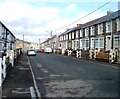
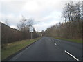
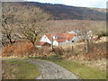
Bournville Road, Bournville
Looking north, in the direction of Blaina, along the main road through the small community of Bournville, Blaenau Gwent.
Image: © Jaggery
Taken: 3 Feb 2011
0.02 miles
2
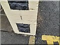
Ordnance Survey Cut Mark
This OS cut mark can be found on the wall of No121 Bournville Road. It marks a point 253.697m above mean sea level.
Image: © Adrian Dust
Taken: 30 Jun 2023
0.02 miles
3
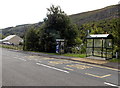
Outdated advert on a Bournville phone box
This mid-September 2013 view across Bournville Road shows that a BT (British Telecom) advert "Bringing it all together for London 2012" remains on the side of the phonebox more than a year after the end of the London Olympics.
Image: © Jaggery
Taken: 18 Sep 2013
0.04 miles
6
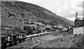
Britannia Halt (remains)
View NW, towards Brynmawr; ex-GWR Newport - Aberbeeg - Brynmawr line. This Halt, called Tyler's Arms until 1933, was between Abertillery and Blaina and was closed on 30/4/62, when the passenger service on the branch ceased; the line was used for coal traffic until 30/7/78.
Image: © Ben Brooksbank
Taken: 14 Jul 1966
0.06 miles
7
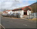
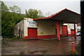
Bournville MoT centre
Located on Bournville Road, at the southern edge of the small community of Bournville, near Blaina.
Image: © Jaggery
Taken: 3 Feb 2011
0.07 miles
8
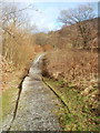
Bournville : footpath into Forestry Commission land
The footpath is on the east side of Bournville Road, accessed through a kissing gate. http://www.geograph.org.uk/photo/2256130
Image: © Jaggery
Taken: 3 Feb 2011
0.07 miles
9
Bournville : detached house viewed from Forestry Commission land
Viewed from a footpath on the east side of Bournville Road. The house is adjacent to Bournville MoT Centre. http://www.geograph.org.uk/photo/2256122
Image: © Jaggery
Taken: 3 Feb 2011
0.07 miles
10
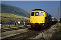
End of The Line (1)
Class 33, 33019 stands on the truncated Aberbeeg - Brynmawr line on the outskirts of Blaina close to Rose Heyworth Colliery. The loco was on the Welsh Washery Wanderer railtour operated by Hertfordshire Railtours. The railtour visited on 28th September 1985 with closure of the colliery due to take place on October 9th, 1985. The railway line would close soon after and the trackbed is now used by the A467 road north of Abertillery.
On the left of the photo is Mynydd Carn-y-cefn.
Image: © Martin Addison
Taken: 28 Sep 1985
0.08 miles