IMAGES TAKEN NEAR TO
Bournville Road, ABERTILLERY, NP13 3ER
Introduction
This page details the photographs taken nearby to Bournville Road, NP13 3ER by members of the Geograph project.
The Geograph project started in 2005 with the aim of publishing, organising and preserving representative images for every square kilometre of Great Britain, Ireland and the Isle of Man.

There are currently over 7.5m images from over14,400 individuals and you can help contribute to the project by visiting https://www.geograph.org.uk
Image Map
Images are licensed for reuse under creativecommons.org/licenses/by-sa/2.0
Notes
- Clicking on the map will re-center to the selected point.
- The higher the marker number, the further away the image location is from the centre of the postcode.
Image Listing (28 Images Found)
Images are licensed for reuse under creativecommons.org/licenses/by-sa/2.0
Image
Details
Distance
1

Ordnance Survey Cut Mark
This OS cut mark can be found on No34 Bournville Road. It marks a point 252.816m above mean sea level.
Image: © Adrian Dust
Taken: 30 Jun 2023
0.01 miles
2
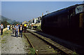
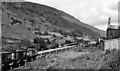
End of The Line (2)
Class 45, 45139 stands on the truncated Aberbeeg - Brynmawr line on the outskirts of Blaina close to Rose Heyworth Colliery. The loco was on the Welsh Washery Wanderer railtour operated by Hertfordshire Railtours. The railtour visited on 28th September 1985 with closure of the colliery due to take place on October 9th, 1985. The railway line would close soon after and the trackbed is now used by the A467 road north of Abertillery. The houses on Bournville Road are visible in the centre beyond the locomotive.
Image: © Martin Addison
Taken: 28 Sep 1985
0.03 miles
3
KTB's Carpets & Beds, Bournville
The shop is at 8 Bournville Road, a few metres into Bournville, a small community south of Blaina.
Image: © Jaggery
Taken: 18 Sep 2013
0.04 miles
4
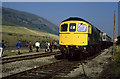
End of The Line (1)
Class 33, 33019 stands on the truncated Aberbeeg - Brynmawr line on the outskirts of Blaina close to Rose Heyworth Colliery. The loco was on the Welsh Washery Wanderer railtour operated by Hertfordshire Railtours. The railtour visited on 28th September 1985 with closure of the colliery due to take place on October 9th, 1985. The railway line would close soon after and the trackbed is now used by the A467 road north of Abertillery.
On the left of the photo is Mynydd Carn-y-cefn.
Image: © Martin Addison
Taken: 28 Sep 1985
0.07 miles
5
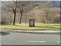
War memorial, Bournville, Blaenau Gwent
On the west side of Bournville Road, adjacent to the William Basil Powell Memorial Hall. http://www.geograph.org.uk/photo/2256213
Image: © Jaggery
Taken: 3 Feb 2011
0.07 miles
6
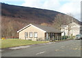
The William Basil Powell Memorial Hall, Bournville
Community centre, Bournville Road, Bournville, Blaenau Gwent.
Image: © Jaggery
Taken: 3 Feb 2011
0.07 miles
7
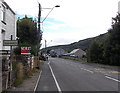
Northern boundary of Bournville
Bournville Road leaves Blaina and enters the small community of Bournville in Blaenau Gwent.
Image: © Jaggery
Taken: 18 Sep 2013
0.09 miles
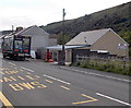
8
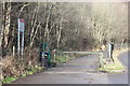
Gated Old Blaina Road
The old road is now closed as a highway; only pedestrians and cycles allowed through on the Ebbw Fach Trail / National Cycle Route 465. The road on the right leads up to the A467.
Image: © M J Roscoe
Taken: 16 Feb 2018
0.09 miles
9
Britannia Halt (remains)
View NW, towards Brynmawr; ex-GWR Newport - Aberbeeg - Brynmawr line. This Halt, called Tyler's Arms until 1933, was between Abertillery and Blaina and was closed on 30/4/62, when the passenger service on the branch ceased; the line was used for coal traffic until 30/7/78.
Image: © Ben Brooksbank
Taken: 14 Jul 1966
0.09 miles
10
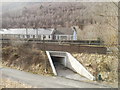
South Griffin Terrace, Blaina
The view from Bournville Road, past an underpass beneath the A467, towards South Griffin Terrace.
Image: © Jaggery
Taken: 3 Feb 2011
0.09 miles