IMAGES TAKEN NEAR TO
Rising Sun Industrial Estate, ABERTILLERY, NP13 3DQ
Introduction
This page details the photographs taken nearby to Rising Sun Industrial Estate, NP13 3DQ by members of the Geograph project.
The Geograph project started in 2005 with the aim of publishing, organising and preserving representative images for every square kilometre of Great Britain, Ireland and the Isle of Man.

There are currently over 7.5m images from over14,400 individuals and you can help contribute to the project by visiting https://www.geograph.org.uk
Image Map
Images are licensed for reuse under creativecommons.org/licenses/by-sa/2.0
Notes
- Clicking on the map will re-center to the selected point.
- The higher the marker number, the further away the image location is from the centre of the postcode.
Image Listing (34 Images Found)
Images are licensed for reuse under creativecommons.org/licenses/by-sa/2.0
Image
Details
Distance
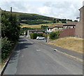
1
From road to path, Coalbrookvale, Nantyglo
The road descending from Queen Street ends here at a path to the A467.
Image: © Jaggery
Taken: 26 Jul 2013
0.13 miles
3
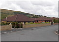
Gwaun Delyn Close bungalows, Nantyglo
On the west side of Queen Street, Nantyglo.
Image: © Jaggery
Taken: 26 Jul 2013
0.13 miles
4
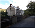
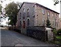
Berea Cottages, Blaina
The cottages are located near the former Berea United Reformed Chapel, now a masjid. http://www.geograph.org.uk/photo/3659906
Image: © Jaggery
Taken: 18 Sep 2013
0.14 miles
5
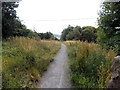
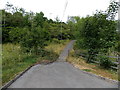
Ebbw Fach Trail heads away from Coalbrookvale, Nantyglo
Viewed from this http://www.geograph.org.uk/photo/3571772 entrance.
Image: © Jaggery
Taken: 26 Jul 2013
0.15 miles
6
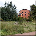
West side of Berea Masjid, Blaina
The masjid http://www.geograph.org.uk/photo/3659906 occupies the converted former Berea United Reformed Chapel.
Image: © Jaggery
Taken: 18 Sep 2013
0.15 miles
7
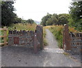
Coalbrookvale entrance to the Ebbw Fach Trail, Nantyglo
The Ebbw Fach Valley was an important industrial area for the iron and coal industry. Removal of industrial scars by land reclamation and environmental improvements has made it a better place to live, work and walk. The 16 km long Ebbw Fach Trail links 14 community green spaces with a variety of amenities, from Beaufort Hill Woodlands in the north to Llanhilleth in the south.
Image: © Jaggery
Taken: 26 Jul 2013
0.16 miles
8
Berea Masjid in Blaina
Operated by the Imaan Islamic Society, the Sunni (Traditional) masjid (mosque) occupies the converted former Berea United Reformed Chapel.
Image: © Jaggery
Taken: 18 Sep 2013
0.16 miles
9
Road to Coalbrookvale, Nantyglo
Viewed from opposite Dale View. http://www.geograph.org.uk/photo/3571721
The road from Queen Street descends towards Coalbrookvale.
Image: © Jaggery
Taken: 26 Jul 2013
0.16 miles
10
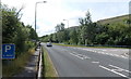
Right turn for Coalbrookvale, Nantyglo
Viewed across the A467 at the western edge of Nantyglo. The path on the left is part of National Cycle Network route 465.
Image: © Jaggery
Taken: 26 Jul 2013
0.16 miles