IMAGES TAKEN NEAR TO
Penrhiw, ABERTILLERY, NP13 2GY
Introduction
This page details the photographs taken nearby to Penrhiw, NP13 2GY by members of the Geograph project.
The Geograph project started in 2005 with the aim of publishing, organising and preserving representative images for every square kilometre of Great Britain, Ireland and the Isle of Man.

There are currently over 7.5m images from over14,400 individuals and you can help contribute to the project by visiting https://www.geograph.org.uk
Image Map
Images are licensed for reuse under creativecommons.org/licenses/by-sa/2.0
Notes
- Clicking on the map will re-center to the selected point.
- The higher the marker number, the further away the image location is from the centre of the postcode.
Image Listing (23 Images Found)
Images are licensed for reuse under creativecommons.org/licenses/by-sa/2.0
Image
Details
Distance

4
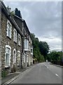
Below Commercial Road
The B4471 Commercial Road, supported by brick arches, clings to the hillside above the Newport to Ebbw Vale railway line.
Image: © Martin Addison
Taken: 28 Sep 1985
0.14 miles
5
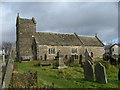
St Illtyds Church
Reported to be the oldest building in NW Gwent
Image: © phil matthews
Taken: 20 Jan 2006
0.15 miles
6

Brynithel from the air
Viewed from a Bristol bound flight from Glasgow.
Image: © Thomas Nugent
Taken: 11 Oct 2010
0.15 miles
8
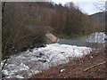
Aberbeeg Gauging Station, Ebbw River
The building was erected in 2014, following extensive reconstruction of the adjacent weir. The top of the weir can be seen to the left.
Image: © M J Roscoe
Taken: 30 Jul 2015
0.19 miles
9
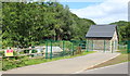
Ebbw River, near Railway Terrace, Aberbeeg
Looking downstream from river bed towards Aberbeeg Weir. Building on the left is Aberbeeg RFC clubhouse. Photographed from same position as Image
Image: © M J Roscoe
Taken: 30 Jul 2015
0.20 miles
10
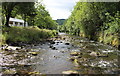
Aberbeeg Weir, Ebbw River
Looking downstream at weir recently reconstructed to allow passage of salmonids and eels; building on left is new gauging station. Formerly the river here formed a loop to the left (east), but around the middle of the last century the present straight course was engineered.
Image: © M J Roscoe
Taken: 30 Jul 2015
0.20 miles