IMAGES TAKEN NEAR TO
Pantddu Road, ABERTILLERY, NP13 2BP
Introduction
This page details the photographs taken nearby to Pantddu Road, NP13 2BP by members of the Geograph project.
The Geograph project started in 2005 with the aim of publishing, organising and preserving representative images for every square kilometre of Great Britain, Ireland and the Isle of Man.

There are currently over 7.5m images from over14,400 individuals and you can help contribute to the project by visiting https://www.geograph.org.uk
Image Map
Images are licensed for reuse under creativecommons.org/licenses/by-sa/2.0
Notes
- Clicking on the map will re-center to the selected point.
- The higher the marker number, the further away the image location is from the centre of the postcode.
Image Listing (121 Images Found)
Images are licensed for reuse under creativecommons.org/licenses/by-sa/2.0
Image
Details
Distance
1
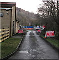
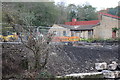
Danger - Construction Site - Keep Out, Aberbeeg
Beyond Aberbeeg Funeral Home http://www.geograph.org.uk/photo/5596996 viewed in December 2016.
Image: © Jaggery
Taken: 9 Dec 2016
0.03 miles
2
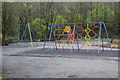
Playground, Aberbeeg
Children's playground near Aberbeeg Community Centre and new cycle lane. The bushes to the right of the playground have been removed recently.
Image: © M J Roscoe
Taken: 30 Mar 2017
0.04 miles
3
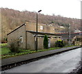
Aberbeeg Funeral Home, Aberbeeg
Independent funeral directors located near Aberbeeg Community Centre. http://www.geograph.org.uk/photo/5596994
Image: © Jaggery
Taken: 9 Dec 2016
0.04 miles
4
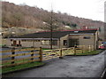
Aberbeeg Community Centre, Aberbeeg
Viewed in December 2016. The building was formerly Aberbeeg Senior Citizens Hall.
Image: © Jaggery
Taken: 9 Dec 2016
0.04 miles
5
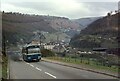
Jones the Bus, Aberbeeg ? 1974
Climbing the steep Pant Ddu Road out of Aberbeeg en route to Crumlin via Pentwyn and Trinant.
Jones' Omnibus Services Ltd - "Jones the bus" - was a local family business based in Aberbeeg, but sold out to the National Bus Company in 1969. It ran a fleet of around 40 buses and coaches with a network of routes which reached as far as Newport. It continued for several years to operate as a separate unit, retaining a distinctive blue livery instead of either of the NBC's standard leaf green or poppy red colours. (The original Jones' blue was a slightly lighter shade.)
The bus is a Leyland Leopard with Willowbrook bodywork, new to Jones in 1968 as no.20, but now numbered U34.68 in the rather idiosyncratic local NBC numbering scheme. Even in 1974 the extent of black exhaust would be frowned upon. Modern emissions regulations ensure that this no longer happens.
This is one of a series of views featuring buses in the 60s, 70s, and 80s. http://www.geograph.org.uk/search.php?i=137652761
Image: © Alan Murray-Rust
Taken: 8 Mar 1975
0.04 miles
6
Bridge construction work, River Ebbw, Aberbeeg, October
The steel rods on top of the bank appear to be the support for the cycle bridge that is to built here across the river. The rectangular concrete pillar (left) next to the damaged bush is the remains of a support for the footbridge which was here in the past.
Image: © M J Roscoe
Taken: 27 Oct 2016
0.05 miles
7
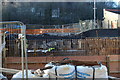
Bridge construction work, River Ebbw, Aberbeeg, November
Looking across the river from the east bank, the concrete support for the new cycle bridge can be seen and in the foreground on the east bank reinforcing rods ready for concrete. The houses in the background are on Pantddu Road.
Image: © M J Roscoe
Taken: 25 Nov 2016
0.05 miles
8
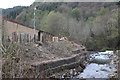
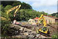
River Ebbw, Aberbeeg
The trees on the river bank have been clear felled to facilitate repair of the gabions at the water's edge; a cycleway bridge may be built here. To the right, looking upstream the Ebbw Fach River flows over a weir into the main river.
Image: © M J Roscoe
Taken: 28 Apr 2016
0.05 miles
9
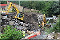
Bridge construction work, River Ebbw, Aberbeeg
Preparation work in the riverbed for pier for a new bridge to carry cycle route 461, and for renovation of the river bank. At top right, the Ebbw Fach River flows over a weir into the main river.
Image: © M J Roscoe
Taken: 24 Aug 2016
0.05 miles
10
Access ramp to bed of River Ebbw, Aberbeeg
Temporary ramp from the west bank into the river to allow construction of a bridge to carry a cycle route; a similar view to Image
Image: © M J Roscoe
Taken: 24 Aug 2016
0.05 miles