IMAGES TAKEN NEAR TO
Glandwr Terrace, ABERTILLERY, NP13 2AJ
Introduction
This page details the photographs taken nearby to Glandwr Terrace, NP13 2AJ by members of the Geograph project.
The Geograph project started in 2005 with the aim of publishing, organising and preserving representative images for every square kilometre of Great Britain, Ireland and the Isle of Man.

There are currently over 7.5m images from over14,400 individuals and you can help contribute to the project by visiting https://www.geograph.org.uk
Image Map
Images are licensed for reuse under creativecommons.org/licenses/by-sa/2.0
Notes
- Clicking on the map will re-center to the selected point.
- The higher the marker number, the further away the image location is from the centre of the postcode.
Image Listing (55 Images Found)
Images are licensed for reuse under creativecommons.org/licenses/by-sa/2.0
Image
Details
Distance
1
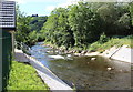
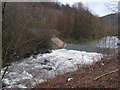
Aberbeeg Weir, Ebbw River
Looking downstream at weir recently reconstructed to allow passage of salmonids and eels; building on left is new gauging station. Formerly the river here formed a loop to the left (east), but around the middle of the last century the present straight course was engineered.
Image: © M J Roscoe
Taken: 30 Jul 2015
0.04 miles
2
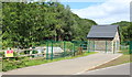
Aberbeeg Gauging Station, Ebbw River
The building was erected in 2014, following extensive reconstruction of the adjacent weir. The top of the weir can be seen to the left.
Image: © M J Roscoe
Taken: 30 Jul 2015
0.05 miles

4
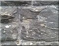
Ordnance Survey Cut Mark
This very damaged OS cut mark can be found on the wall of the school on Commercial Road. It marked a point 173.858m above mean sea level.
Image: © Adrian Dust
Taken: 16 Aug 2021
0.06 miles
5
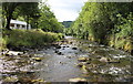
Ebbw River, near Railway Terrace, Aberbeeg
Looking downstream from river bed towards Aberbeeg Weir. Building on the left is Aberbeeg RFC clubhouse. Photographed from same position as Image
Image: © M J Roscoe
Taken: 30 Jul 2015
0.08 miles

10
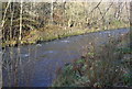
Ebbw River, near Railway Terrace, Aberbeeg, Winter
Looking upstream from almost the same position on the east bank as in Image
Image: © M J Roscoe
Taken: 25 Nov 2011
0.15 miles