IMAGES TAKEN NEAR TO
Cwmtillery, ABERTILLERY, NP13 1JP
Introduction
This page details the photographs taken nearby to NP13 1JP by members of the Geograph project.
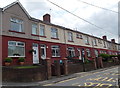
The Geograph project started in 2005 with the aim of publishing, organising and preserving representative images for every square kilometre of Great Britain, Ireland and the Isle of Man.

There are currently over 7.5m images from over14,400 individuals and you can help contribute to the project by visiting https://www.geograph.org.uk
Image Map
Images are licensed for reuse under creativecommons.org/licenses/by-sa/2.0
Notes
- Clicking on the map will re-center to the selected point.
- The higher the marker number, the further away the image location is from the centre of the postcode.
Image Listing (39 Images Found)
Images are licensed for reuse under creativecommons.org/licenses/by-sa/2.0
Image
Details
Distance
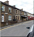
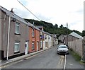
1
Lower Gwastod Terrace, Cwmtillery
Viewed from the southern end of Woodland Terrace.
Image: © Jaggery
Taken: 24 Jun 2013
0.02 miles
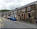
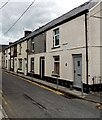
2
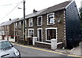
Spring Cottages, Cwmtillery
A row of 3 houses at the northern end of Tillery Road, Cwmtillery.
Image: © Jaggery
Taken: 24 Jun 2013
0.03 miles
3
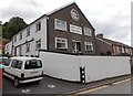
Mynydd Lodge Guest House, Cwmtillery
The Tillery Road guest house providing bed and breakfast accommodation
has been converted from the former Zion chapel.
Image: © Jaggery
Taken: 24 Jun 2013
0.03 miles
4
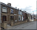
Rices Houses Cwmtillery
The row of 4 houses nearest the camera is named Rices Houses.
The dark red and white houses are in Lower Gwastod Terrace.
Image: © Jaggery
Taken: 24 Jun 2013
0.04 miles
5
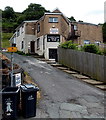
Blaentillery Social Club, Cwmtillery
Set back 20 metres from the east side of Tillery Road.
Image: © Jaggery
Taken: 24 Jun 2013
0.05 miles
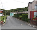
6
Summers Houses, Cwmtillery
There are several separately-named rows of houses in Tillery Road Cwmtillery.
This one is named Summers Houses, located between Mount Pleasant Row behind the camera and Rosegreen Cottages ahead.
Image: © Jaggery
Taken: 24 Jun 2013
0.06 miles
7
Upper Gwastod Terrace, Cwmtillery
Looking towards houses in Upper Gwastod Terrace from Lower Gwastod Terrace.
Image: © Jaggery
Taken: 24 Jun 2013
0.06 miles
8
Woodland Terrace, Cwmtillery
Viewed from the edge of fencing http://www.geograph.org.uk/photo/3532141 enclosing the site of the demolished Top Hat club.
Image: © Jaggery
Taken: 24 Jun 2013
0.06 miles
9
Rosegreen Cottages, Cwmtillery
Rosegreen Cottages are a separately-named row of houses in Tillery Road.
Image: © Jaggery
Taken: 24 Jun 2013
0.06 miles
10
Date tablet, Woodland Terrace, Cwmtillery
The inscription on the tablet on the wall of the house on the right shows
JOSEPH WALLACE WOODLAND TERACE Erected 1876 J.EDMUNDS Builder.
The spelling TERACE is the tablet's error, not mine.
Image: © Jaggery
Taken: 24 Jun 2013
0.07 miles