IMAGES TAKEN NEAR TO
Newbridge Road, BLACKWOOD, NP12 2LB
Introduction
This page details the photographs taken nearby to Newbridge Road, NP12 2LB by members of the Geograph project.
The Geograph project started in 2005 with the aim of publishing, organising and preserving representative images for every square kilometre of Great Britain, Ireland and the Isle of Man.

There are currently over 7.5m images from over14,400 individuals and you can help contribute to the project by visiting https://www.geograph.org.uk
Image Map
Images are licensed for reuse under creativecommons.org/licenses/by-sa/2.0
Notes
- Clicking on the map will re-center to the selected point.
- The higher the marker number, the further away the image location is from the centre of the postcode.
Image Listing (45 Images Found)
Images are licensed for reuse under creativecommons.org/licenses/by-sa/2.0
Image
Details
Distance
1
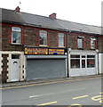
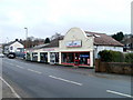
Two shops, three businesses, Pontllanfraith
Occupying the Newbridge Road shop on the left, with different phone numbers, are Dragon Micros (computer sales, repair and upgrade) and Valley Viewing (television sales and repairs, parts and accessories).
Next door on the right, rather inconspicuous without a name board, is a barber shop. There is an image of a comb and scissors on the door and the words Barber Shop on a window pane.
Image: © Jaggery
Taken: 8 Aug 2012
0.08 miles
2
Sunny Fish Bar, Pontllanfraith
Fish & chip shop and Chinese takeaway at 17A Newbridge Road.
Image: © Jaggery
Taken: 8 Aug 2012
0.08 miles
3
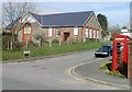
Elim Baptist Church, Pontllanfraith
Located on Elim Way, viewed across Newbridge Road (B4251).
Image: © Jaggery
Taken: 7 Apr 2011
0.08 miles
4
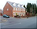
Cwrt Pantycelyn, Pontllanfraith
Housing built in 2004, located at the SE corner of Cwrt Pantycelyn, a small cul-de-sac on the north side of Newbridge Road.
Image: © Jaggery
Taken: 23 Jan 2011
0.08 miles
5
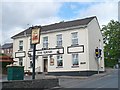
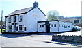
The Plough Inn, Pontllanfraith
Just up the hill from the bridge over the River Sirhowy http://www.geograph.org.uk/photo/2678581 .
Image: © Robin Drayton
Taken: 26 May 2011
0.10 miles
6
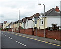
Llanarth Road bungalows, Pontllanfraith
Bungalows on the east side of Llanarth Road, viewed from near the corner of Meadow Road.
Image: © Jaggery
Taken: 8 Aug 2012
0.11 miles
7
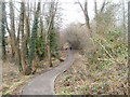
Path to Cwm Philkins, Pontllanfraith
Viewed from near the Newbridge Road end, a path heads towards Cwm Philkins, the site of a former Sirhowy Valley colliery. A variant spelling is Filkins.
Image: © Jaggery
Taken: 23 Jan 2011
0.12 miles
8
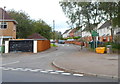
Corner of Meadow Road and Llanarth Road, Pontllanfraith
Viewed across Llanarth Road. A sign next to a yellow grit bin shows that this is the boundary of the Springfield district of Pontllanfraith.
Image: © Jaggery
Taken: 8 Aug 2012
0.12 miles
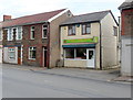
9
Flooring retailers, Pontllanfraith
Quick Step Laminate Floor Centre and next door, Carpet & Flooring Store, located on the south side of Newbridge Road.
Image: © Jaggery
Taken: 23 Jan 2011
0.12 miles
10
Ivor Arms, Pontllanfraith
Pub on the south side of Newbridge Road (B4251) viewed from the corner of the eastern arm of Elim Way.
Image: © Jaggery
Taken: 7 Apr 2011
0.12 miles