1
Pontllanfraith Primary School
Viewed across Penmaen Road. The Infants part of the school is on the right.
Image: © Jaggery
Taken: 8 Aug 2012
0.10 miles
2
Path to Cwm Philkins, Pontllanfraith
Viewed from near the Newbridge Road end, a path heads towards Cwm Philkins, the site of a former Sirhowy Valley colliery. A variant spelling is Filkins.
Image: © Jaggery
Taken: 23 Jan 2011
0.12 miles
3
The Plough Inn, Pontllanfraith
Just up the hill from the bridge over the River Sirhowy http://www.geograph.org.uk/photo/2678581 .
Image: © Robin Drayton
Taken: 26 May 2011
0.13 miles
4
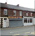
Two shops, three businesses, Pontllanfraith
Occupying the Newbridge Road shop on the left, with different phone numbers, are Dragon Micros (computer sales, repair and upgrade) and Valley Viewing (television sales and repairs, parts and accessories).
Next door on the right, rather inconspicuous without a name board, is a barber shop. There is an image of a comb and scissors on the door and the words Barber Shop on a window pane.
Image: © Jaggery
Taken: 8 Aug 2012
0.14 miles
5
Sunny Fish Bar, Pontllanfraith
Fish & chip shop and Chinese takeaway at 17A Newbridge Road.
Image: © Jaggery
Taken: 8 Aug 2012
0.14 miles
6
Elim Baptist Church, Pontllanfraith
Located on Elim Way, viewed across Newbridge Road (B4251).
Image: © Jaggery
Taken: 7 Apr 2011
0.14 miles
7
Cwrt Pantycelyn, Pontllanfraith
Housing built in 2004, located at the SE corner of Cwrt Pantycelyn, a small cul-de-sac on the north side of Newbridge Road.
Image: © Jaggery
Taken: 23 Jan 2011
0.14 miles
8
Riverside Garage, Penmaen Road, Pontllanfraith
Premises of John Kajzer-Hughes & Son Ltd, located opposite Pontllanfraith Primary School. http://www.geograph.org.uk/photo/3074110
The river that Riverside Garage is beside is the Sirhowy.
Image: © Jaggery
Taken: 8 Aug 2012
0.14 miles
9
Woodfieldside Business Park, Pontllanfraith
Viewed from the entrance road from Penmaen Road.
The business units were partly funded through the European Objective 1 Programme and the Local Regeneration Fund via the Welsh Government. The business park contains 22 business units, designed for light industrial use.
Image: © Jaggery
Taken: 8 Aug 2012
0.15 miles
10
Ivor Arms, Pontllanfraith
Pub on the south side of Newbridge Road (B4251) viewed from the corner of the eastern arm of Elim Way.
Image: © Jaggery
Taken: 7 Apr 2011
0.15 miles


