IMAGES TAKEN NEAR TO
Berllangron, BLACKWOOD, NP12 1BJ
Introduction
This page details the photographs taken nearby to Berllangron, NP12 1BJ by members of the Geograph project.
The Geograph project started in 2005 with the aim of publishing, organising and preserving representative images for every square kilometre of Great Britain, Ireland and the Isle of Man.

There are currently over 7.5m images from over14,400 individuals and you can help contribute to the project by visiting https://www.geograph.org.uk
Image Map
Images are licensed for reuse under creativecommons.org/licenses/by-sa/2.0
Notes
- Clicking on the map will re-center to the selected point.
- The higher the marker number, the further away the image location is from the centre of the postcode.
Image Listing (58 Images Found)
Images are licensed for reuse under creativecommons.org/licenses/by-sa/2.0
Image
Details
Distance
1
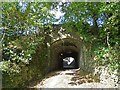
Disused railway bridge
In fact, this is two bridges.
The railway which once crossed this bridge in the foreground has long gone.
Immediately behind it is a modern bridge which carries the A4048 which was realigned at this point when the Chartist Bridge http://www.geograph.org.uk/photo/601707 was constructed.
The location of this picture is just to the right of centre in this view http://www.geograph.org.uk/photo/872167 .
Image: © Robin Drayton
Taken: 8 Oct 2009
0.07 miles
4
View near the Chartist Bridge
Taken from near to the western end of the Chartist Bridge and showing the A4048 northwards towards Tredegar.
Image: © Robin Drayton
Taken: 3 Jul 2008
0.08 miles
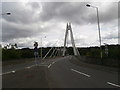
5
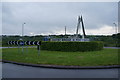
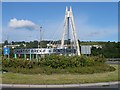
Roundabout at the west end of Chartist Bridge
Image: © Ian S
Taken: 25 May 2014
0.09 miles
6
Chartist Bridge, Blackwood
For details of this bridge see http://www.arup.com/bridges/project.cfm?pageid=8826
Image: © Robin Drayton
Taken: 2 Nov 2007
0.09 miles
7
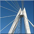
Chartist Bridge (detail)
http://www.arup.com/bridges/project.cfm?pageid=8826
Image: © Robin Drayton
Taken: 3 Jul 2008
0.09 miles
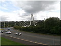
8
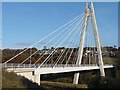
Chartist Bridge / Pont y Siartwyr across the Sirhowy Valley at Blackwood
A pretty stunning and attractive newish (2005) bridge which commemorates the Chartist movement locally back in the winter of 1839. So doubly striking and significant.
The Chartist Bridge is a cable-stayed bridge some 230m long, supported 30m above the wooded valley floor by a 90m A-frame pylon. Difficulties with mining related subsidence during construction, and in its foreseeable lifetime, led the Cardiff-based Ove-Arup design team to allow the bridge 'to breathe' if settlement does occur. The road bridge and the Sirhowy Enterprise Way, of which it forms a key part, are owned and operated by Costain & Lang Construction in a JV, under a 30 year DBFO (Design, Build, Finance, Operate) agreement and now
links the east and west sides of the Sirhowy Valley, which previously necessitated a frustrating detour down, or up, a steep 1-in-4 hill road on the valley bottom, known locally as the Rhiw.
Image: © Jeremy Bolwell
Taken: 14 Oct 2012
0.10 miles
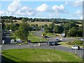
9
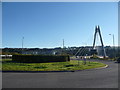
Roundabout and Chartist Bridge
Situated at the western end of the Chartist Bridge.
Image: © Robin Drayton
Taken: 3 Jul 2008
0.10 miles
10
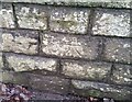
Ordnance Survey Cut Mark
This OS cut mark can be found on NW buttress/wall of the old railway bridge which runs under High Street. It marks a point 179.478m above mean sea level.
Image: © Adrian Dust
Taken: 5 Feb 2021
0.10 miles