IMAGES TAKEN NEAR TO
Oakdale, BLACKWOOD, NP12 0NE
Introduction
This page details the photographs taken nearby to NP12 0NE by members of the Geograph project.
The Geograph project started in 2005 with the aim of publishing, organising and preserving representative images for every square kilometre of Great Britain, Ireland and the Isle of Man.

There are currently over 7.5m images from over14,400 individuals and you can help contribute to the project by visiting https://www.geograph.org.uk
Image Map
Images are licensed for reuse under creativecommons.org/licenses/by-sa/2.0
Notes
- Clicking on the map will re-center to the selected point.
- The higher the marker number, the further away the image location is from the centre of the postcode.
Image Listing (58 Images Found)
Images are licensed for reuse under creativecommons.org/licenses/by-sa/2.0
Image
Details
Distance
1
Llys Pentwyn-uchaf Farm, Oakdale
Farm, and The Barn to its right, viewed across the Nant Philkins from edge of new housing estate.
Image: © M J Roscoe
Taken: 11 Sep 2022
0.02 miles
2
Llys Pentwyn-Uchaf Farm, Oakdale
View to working farm across Coed Cwm Philkins SINC.
Image: © M J Roscoe
Taken: 29 Apr 2020
0.02 miles
3
Track to Llys-pentwyn-uchaf, Oakdale
Farm track from Llwyn-on Lane, viewed from the gate shown in Image
Image: © M J Roscoe
Taken: 5 Feb 2016
0.05 miles
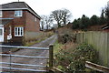
4
Track down from Llys-pentwyn-uchaf, Oakdale
Farm track between housing estates to Llwyn-on Lane.
Image: © M J Roscoe
Taken: 5 Feb 2016
0.08 miles
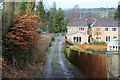
5
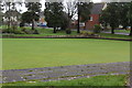
Bowling green in winter, Oakdale
Bowling green, Oakdale Recreation Ground, with Llwyn-on Lane in background.
Image: © M J Roscoe
Taken: 6 Dec 2015
0.10 miles
6
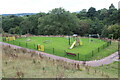
New playground below Sycamore Gardens
Playground on grass on hillside above the Nant Philkins.
Image: © M J Roscoe
Taken: 11 Sep 2022
0.10 miles
7
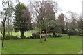
Lawn and bowling green, Oakdale
Birch and other trees in a corner of Oakdale Recreation Ground; an almost opposite view to that in Image
Image: © M J Roscoe
Taken: 6 Dec 2015
0.11 miles
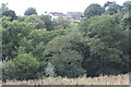
8
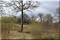
Pasture, Cwm Philkins, near Llys-pentwyn-uchaf
Pasture, and woodland on the far side of Nant Philkins, near the head of Cwm Philkins. The woodland is part of the Coed Cwm Philkins Site of Importance for Nature Conservation.
Image: © M J Roscoe
Taken: 17 Apr 2016
0.11 miles
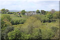
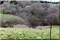
9
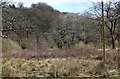
Pasture, Cwm Philkins, below Llys-pentwyn-uchaf
A marshy, somewhat overgrown field; the line of the little used footpath is not apparent and appears to be covered by brambles.
Image: © M J Roscoe
Taken: 24 Apr 2016
0.12 miles
10
Cwm Philkins below Llys-pentwyn-uchaf
Marshy overgrown pasture near the head of the valley. The line of the little used footpath down to Nant Philkins Image is not apparent. Cincoed Farm is just visible on the skyline.
Image: © M J Roscoe
Taken: 17 Apr 2016
0.12 miles