IMAGES TAKEN NEAR TO
Llwyn-On Crescent, BLACKWOOD, NP12 0ND
Introduction
This page details the photographs taken nearby to Llwyn-On Crescent, NP12 0ND by members of the Geograph project.
The Geograph project started in 2005 with the aim of publishing, organising and preserving representative images for every square kilometre of Great Britain, Ireland and the Isle of Man.

There are currently over 7.5m images from over14,400 individuals and you can help contribute to the project by visiting https://www.geograph.org.uk
Image Map
Images are licensed for reuse under creativecommons.org/licenses/by-sa/2.0
Notes
- Clicking on the map will re-center to the selected point.
- The higher the marker number, the further away the image location is from the centre of the postcode.
Image Listing (97 Images Found)
Images are licensed for reuse under creativecommons.org/licenses/by-sa/2.0
Image
Details
Distance
1
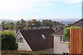
View over Oakdale
View southwest from the highest point in the village, the houses in the foreground are on Maes-y-garn Road.
Image: © M J Roscoe
Taken: 21 Oct 2016
0.05 miles
2
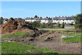
Entrance area, former Oakdale Golf Course
The main entrance (right) is off Llwyn On Lane. The brown mounds (left) appear to be wood chippings from the trees and bushes that have removed to make way for a housing estate.
Image: © M J Roscoe
Taken: 29 Sep 2018
0.06 miles
3
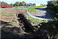
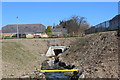
Nant Philkins, next to Llwyn on Lane
Man-made channel of the stream, which here is the overflow from the pond Image near the entrance to the former golf course, before disappearing underground again. It will probably be in a culvert as it will be on the edge of a new housing estate. The low plastic fence is to restrict the movement of reptiles.
Image: © M J Roscoe
Taken: 29 Sep 2018
0.06 miles
4
House under construction
Construction site behind Bungalow Club, Llwynon Lane.
Image: © M J Roscoe
Taken: 22 Aug 2021
0.06 miles
5
Realigned Nant Philkins, Sycamore Gardens
The stream emerges now from a culvert (under construction Image) under a new road, Cae'r Delyn and through the site formerly partly occupied by a pond Image The new housing estate is to the right.
Image: © M J Roscoe
Taken: 26 Mar 2020
0.07 miles
6
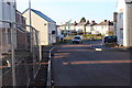
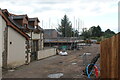
Cae'r Delyn, Sycamore Gardens, Oakdale
Looking northwest on road into new housing estate with houses on Llwyn on Lane in the background. Some of the new houses on now occupied though the roads have not had their final surface.
Image: © M J Roscoe
Taken: 25 Dec 2019
0.07 miles
7
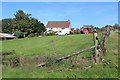
Rear of Gelli-gynnes, Oakdale
The house is on a minor road and the rear field borders the edge of the former golf driving range (right).
Image: © M J Roscoe
Taken: 29 Sep 2018
0.07 miles
8
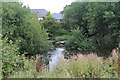
Pond, off Llwyn on Lane, Oakdale
Somewhat overgrown pond which will be modified as it will be on the edge of a new housing estate to the right on a former golf course.
Image: © M J Roscoe
Taken: 13 Aug 2018
0.08 miles
9
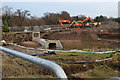
Pipes & pond on construction site
The edge of a construction site for new houses to the right on the former Oakdale Golf Course. There was a pond Image near the opening of the pipes. The pipe carries the modified Nant Philkins which has flooded the land downstream of the opening of the pipe.
Image: © M J Roscoe
Taken: 24 Dec 2018
0.08 miles
10
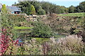
Pond(2), off Llwyn on Lane, Oakdale
The trees and bushes have been cleared from one side of the pond Image prior to eventually modifying the area when it becomes part of the housing estate on the former golf course to the right.
Image: © M J Roscoe
Taken: 29 Sep 2018
0.08 miles