IMAGES TAKEN NEAR TO
Manmoel Road, BLACKWOOD, NP12 0HY
Introduction
This page details the photographs taken nearby to Manmoel Road, NP12 0HY by members of the Geograph project.
The Geograph project started in 2005 with the aim of publishing, organising and preserving representative images for every square kilometre of Great Britain, Ireland and the Isle of Man.

There are currently over 7.5m images from over14,400 individuals and you can help contribute to the project by visiting https://www.geograph.org.uk
Image Map
Images are licensed for reuse under creativecommons.org/licenses/by-sa/2.0
Notes
- Clicking on the map will re-center to the selected point.
- The higher the marker number, the further away the image location is from the centre of the postcode.
Image Listing (31 Images Found)
Images are licensed for reuse under creativecommons.org/licenses/by-sa/2.0
Image
Details
Distance
1
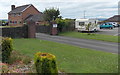
Manager's house, Penyfan Caravan and Leisure Park
Viewed from Manmoel Road. The house is on the NE side of the park.
Image: © Jaggery
Taken: 13 Jul 2014
0.01 miles
2
Weight limit ahead, Pen-Deri Farm Lane
The sign showing a 7.5 tonnes limit ahead is near the Manmoel Road junction (behind the camera).
Image: © Jaggery
Taken: 13 Jul 2014
0.02 miles
3
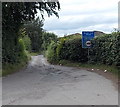
Ignore satellite navigation, Manmoel Road
Partly obscured by vegetation, two signs are on the corner of Manmoel Road and Pen-Deri Farm Lane. The upper blue sign shows Unsuitable for heavy goods vehicles. The lower white sign shows Ignore satellite navigation.
Image: © Jaggery
Taken: 13 Jul 2014
0.02 miles
5
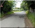
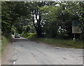
Warning sign on the approach to Smugglers Run
The triangular warning sign is alongside Manmoel Road near the left turn for Smugglers Run showground and livery yard. http://www.geograph.org.uk/photo/4072959
Image: © Jaggery
Taken: 13 Jul 2014
0.03 miles
6
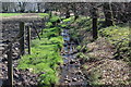
Roadside stream, Manmoel Road
Looking downstream alongside Manmoel Road, near Penyfan Caravan Rark; the field on the left is used by horses.
Image: © M J Roscoe
Taken: 6 Apr 2017
0.04 miles
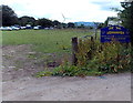
7
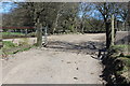
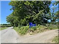
New byway off Manmoel Road
Newly constructed dirt track near Penyfan Caravan Park; the track, judging by a council sign (horse and wagon) at the roadside, is a byway.
Image: © M J Roscoe
Taken: 6 Apr 2017
0.04 miles
8
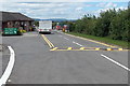
New arrival at Penyfan Caravan and Leisure Park
A few moments ago, the vehicle stopped at the security barrier entered the park from Manmoel Road.
Image: © Jaggery
Taken: 13 Jul 2014
0.05 miles
9
Entrance to Smugglers Run showground and livery yard near Manmoel
From Pen-Deri Farm Lane, at the edge of Penyfan Caravan and Leisure Park.
Image: © Jaggery
Taken: 13 Jul 2014
0.05 miles
10
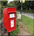
Postbox at the entrance to Penyfan Caravan and Leisure Park
Located here. http://www.geograph.org.uk/photo/4073135
The label stuck on the box states that with effect from April 12th 2014,
the last Saturday collection from this box will be at 10:00.
This is the same time as that shown for Saturdays lower down.
Image: © Jaggery
Taken: 13 Jul 2014
0.05 miles