IMAGES TAKEN NEAR TO
Pen-Rhiw Avenue, BLACKWOOD, NP12 0FA
Introduction
This page details the photographs taken nearby to Pen-Rhiw Avenue, NP12 0FA by members of the Geograph project.
The Geograph project started in 2005 with the aim of publishing, organising and preserving representative images for every square kilometre of Great Britain, Ireland and the Isle of Man.

There are currently over 7.5m images from over14,400 individuals and you can help contribute to the project by visiting https://www.geograph.org.uk
Image Map
Images are licensed for reuse under creativecommons.org/licenses/by-sa/2.0
Notes
- Clicking on the map will re-center to the selected point.
- The higher the marker number, the further away the image location is from the centre of the postcode.
Image Listing (80 Images Found)
Images are licensed for reuse under creativecommons.org/licenses/by-sa/2.0
Image
Details
Distance
1
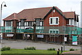
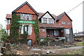
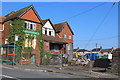
Former Oakdale Public House, Oakdale
The front of the partly renovated Grade II listed building on Penrhiw Avenue. Externally renovation of the upper storeys of the formerly derelict pub appears to have been largely completed; new windows installed. For side view on same day, see Image The building is being converted into nine apartments by the Pobl Housing Association.
Image: © M J Roscoe
Taken: 8 Apr 2018
0.01 miles
2
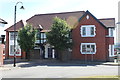
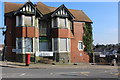
Oakdale House, Pen-rhiw Avenue, Oakdale
The former disused Oakdale Hotel, Grade II listed, now converted into nine apartments for the Pobl Group.
Image: © M J Roscoe
Taken: 24 Jun 2018
0.01 miles
3
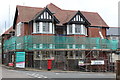
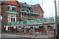
Former Oakdale Public House (2), Oakdale
Side view of partly renovated, formerly derelict, pub to nine apartments of this grade II listed pub. For the front on the same day see Image and a year ago, see Image On the right is part of one of the three terraced houses under construction in the former yard of the pub.
Image: © M J Roscoe
Taken: 8 Apr 2018
0.01 miles
4
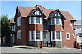
Oakdale House, Central Avenue, Oakdale
The former disused Oakdale Hotel, Grade II listed, renovated as nine apartments for the Pobl Group. The former doorway on this side has been closed. For a view of the disused hotel/public house, see Image
Image: © M J Roscoe
Taken: 24 Jun 2018
0.01 miles
5
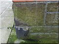
Ordnance Survey Cut Mark
This OS cut mark can be found on The Oakdale Public House . It marks a point 245.230m above mean sea level.
Image: © Adrian Dust
Taken: 9 Feb 2021
0.01 miles
6
Rear view of Oakdale Hotel, Oakdale
This disused public house, a grade II listed building, is to be converted into apartments. On the left can be seen the stumps of recently felled lime trees. A row of terraced houses will be built in this area. For an earlier view of the front of the hotel, see Image
Image: © M J Roscoe
Taken: 1 Apr 2016
0.01 miles
7
Former Oakdale Public House, Central Avenue, Oakdale
This grade II listed former public house is being converted into apartments; the rear of the building on the same day is shown in Image
Image: © M J Roscoe
Taken: 7 Apr 2017
0.01 miles
8
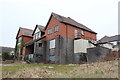
Rear of Oakdale Hotel, Oakdale
This disused public house, a Grade II listed building, is to be converted into apartments. The grounds will be used for housing and car parking.
Image: © M J Roscoe
Taken: 1 Apr 2016
0.01 miles
9
Rear of former Oakdale Public House Oakdale
Conversion of this grade II listed building Image to apartments is now underway. In addition a row of three terraced houses will be built in the yard immediately behind the security fence; the stone wall having been demolished for use elsewhere on the site.
Image: © M J Roscoe
Taken: 7 Apr 2017
0.01 miles
10
Conversion & renovation of the former Oakdale Public House, Oakdale
A row of three terraced houses is under construction alongside the pavement, whilst behind the Grade II listed disused pub is being repaired and converted to apartments. For an earlier phase, April 2017, see Image
Image: © M J Roscoe
Taken: 24 Jul 2017
0.01 miles