IMAGES TAKEN NEAR TO
The Rock, BLACKWOOD, NP12 0AD
Introduction
This page details the photographs taken nearby to NP12 0AD by members of the Geograph project.
The Geograph project started in 2005 with the aim of publishing, organising and preserving representative images for every square kilometre of Great Britain, Ireland and the Isle of Man.

There are currently over 7.5m images from over14,400 individuals and you can help contribute to the project by visiting https://www.geograph.org.uk
Image Map
Images are licensed for reuse under creativecommons.org/licenses/by-sa/2.0
Notes
- Clicking on the map will re-center to the selected point.
- The higher the marker number, the further away the image location is from the centre of the postcode.
Image Listing (37 Images Found)
Images are licensed for reuse under creativecommons.org/licenses/by-sa/2.0
Image
Details
Distance
1

Entrance road to Argoed Fawr farm
Viewed from the A4048. The farm is about 250 metres distant.
Image: © Jaggery
Taken: 1 Mar 2010
0.02 miles
2
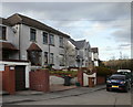
Rock Villas, The Rock
The Rock (Y Graig in Welsh) is a small community alongside the A4048 midway between Argoed and Blackwood. Rock Villas are on the west side of a bend in the A4048.
Image: © Jaggery
Taken: 1 Mar 2010
0.08 miles
3
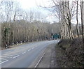
A4048 approaches The Rock
The green sign alongside a bend in the A4048 marks the northern boundary of The Rock (Y Graig in Welsh), on the approach from Argoed.
Image: © Jaggery
Taken: 1 Mar 2010
0.08 miles
4
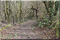
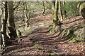
Sirhowy Valley Walk below Argoed fawr
Footpath through woodland from dismantled railway down to footbridge over the River Sirhowy.
Image: © M J Roscoe
Taken: 13 Apr 2016
0.09 miles
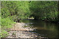
5
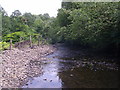
River Sirhowy, south of Argoed
Looking downstream from underneath footbridge carrying Sirhowy Valley Walk.
Image: © M J Roscoe
Taken: 8 Jul 2015
0.10 miles
6
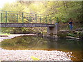
Squires Bridge over the Sirhowy
A quiet footpath bridge over the Sirhowy river. Now a clean and beautiful river the mines that formerly poisoned it long gone.
Image: © nantcoly
Taken: 12 May 2006
0.11 miles
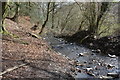
7
River Sirhowy south of Grwhay
Looking downstream.
Image: © M J Roscoe
Taken: 29 May 2016
0.12 miles
8
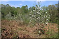
Apple orchard, The Rock
Unfenced orchard on side of landscaped wooded coal waste tip next to footpath (right, out of shot) all part of Blackwood Riverside SINC.
Image: © M J Roscoe
Taken: 25 Apr 2020
0.12 miles
9
Nant Grwhay below Grwhay
This stream flows into the River Sirhowy; looking downstream from the bottom of the flight of steps in Image
Image: © M J Roscoe
Taken: 13 Apr 2016
0.13 miles
10
Woodland steps to Nant Grwhay, below Grwhay
Flight of steps, public footpath, from the direction of demolished dwellings to a gate next to the stream.
Image: © M J Roscoe
Taken: 13 Apr 2016
0.13 miles