IMAGES TAKEN NEAR TO
Nine Mile Point Road, NEWPORT, NP11 7QT
Introduction
This page details the photographs taken nearby to Nine Mile Point Road, NP11 7QT by members of the Geograph project.
The Geograph project started in 2005 with the aim of publishing, organising and preserving representative images for every square kilometre of Great Britain, Ireland and the Isle of Man.

There are currently over 7.5m images from over14,400 individuals and you can help contribute to the project by visiting https://www.geograph.org.uk
Image Map
Images are licensed for reuse under creativecommons.org/licenses/by-sa/2.0
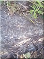
Notes
- Clicking on the map will re-center to the selected point.
- The higher the marker number, the further away the image location is from the centre of the postcode.
Image Listing (86 Images Found)
Images are licensed for reuse under creativecommons.org/licenses/by-sa/2.0
Image
Details
Distance
1
Ordnance Survey Rivet
This OS rivet can be found on the step NW side of the road. It marks a point 110.969m above mean sea level.
Image: © Adrian Dust
Taken: 22 Jun 2019
0.04 miles
2
Bent Please Drive Safely sign, Brynawel
The distorted shape of the green sign at the spot where Nine Mile Point Road, Wattsville, becomes Duffryn Road, Brynawel suggests that at least one driver has not observed its Please Drive Safely message.
Image: © Jaggery
Taken: 26 May 2010
0.05 miles
3
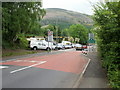
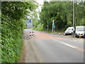
Traffic calming at western edge of Wattsville
At this point along the A4048, Duffryn Road, Brynawel becomes Nine Mile Point Road, Wattsville. Adjacent to the Wattsville sign, the road briefly narrows as a traffic calming measure.
Image: © Jaggery
Taken: 26 May 2010
0.05 miles
4
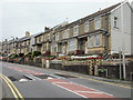
Nine Mile Point Road, Wattsville
Houses on the north side of the road, viewed from opposite the turning for Troed-y-Rhiw Road.
Image: © Jaggery
Taken: 26 May 2010
0.05 miles
5
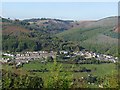
View of Brynawel
Taken from the edge of Mynydd Machen Common.
Looking across the Sirhowy Valley towards Brynawel with the slopes of Mynydd y Lan on the right.
Image: © Robin Drayton
Taken: 14 Oct 2009
0.05 miles
6
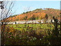
View across the Sirhowy
Looking at the terraced housing of Brynawel beneath the wooded Craig-y-trwyn.
Image: © Jonathan Billinger
Taken: 11 Nov 2008
0.08 miles
7
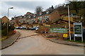
Woodside Walk, Wattsville
Recently-built houses viewed from Troed-y-Rhiw Road.
Image: © Jaggery
Taken: 16 Mar 2012
0.10 miles
8
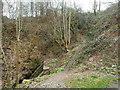
Steep muddy track, Wattsville
Near an underpass http://www.geograph.org.uk/photo/2852104 a narrow muddy track climbs away from the road. The masonry on the left is part of a culvert http://www.geograph.org.uk/photo/2852146 from which a stream, Nant Hafod-tudur, issues.
Image: © Jaggery
Taken: 16 Mar 2012
0.11 miles
9
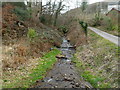
Stream between two culverts, Wattsville
After emerging from a culvert http://www.geograph.org.uk/photo/2852146 out of shot ahead,
Nant Hafod-tudur flows towards another one. http://www.geograph.org.uk/photo/2852167
The stream is a tributary of the Sirhowy.
Image: © Jaggery
Taken: 16 Mar 2012
0.11 miles
10
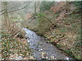
Nant Hafod-tudur, Wattsville
After emerging from a culvert http://www.geograph.org.uk/photo/2852146, the stream flows towards its end at the Sirhowy River, about 250 metres away.
Image: © Jaggery
Taken: 16 Mar 2012
0.11 miles