IMAGES TAKEN NEAR TO
Duffryn Terrace, NEWPORT, NP11 7QN
Introduction
This page details the photographs taken nearby to Duffryn Terrace, NP11 7QN by members of the Geograph project.
The Geograph project started in 2005 with the aim of publishing, organising and preserving representative images for every square kilometre of Great Britain, Ireland and the Isle of Man.

There are currently over 7.5m images from over14,400 individuals and you can help contribute to the project by visiting https://www.geograph.org.uk
Image Map
Images are licensed for reuse under creativecommons.org/licenses/by-sa/2.0
Notes
- Clicking on the map will re-center to the selected point.
- The higher the marker number, the further away the image location is from the centre of the postcode.
Image Listing (81 Images Found)
Images are licensed for reuse under creativecommons.org/licenses/by-sa/2.0
Image
Details
Distance
1
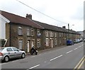
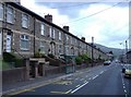
Row of houses, Islwyn Road, Wattsville
The 70-metre long row on the south side of Islwyn Road contains 14 houses. The far end of the row is at the Duffryn Terrace junction.
Image: © Jaggery
Taken: 16 Mar 2012
0.02 miles
2
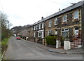
Duffryn Terrace houses, Wattsville
The main course of Duffryn Terrace run parallel with Islwyn Road which is 60 metres to the north. There are houses on only one side of the street. The other side is the north bank of the Sirhowy River.
Viewed from near the southern side of Bethel church. http://www.geograph.org.uk/photo/2852055
Image: © Jaggery
Taken: 16 Mar 2012
0.04 miles
3
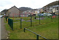
Duffryn Terrace playground, Wattsville
Located in a 40-metre gap in the houses. Numbers 17 to 23 Duffryn Terrace formerly occupied this area. One reference source states that the missing houses were destroyed in a bombing raid in the Second World War. However, a correspondent has informed me that the houses were demolished because of subsidence caused by a mine collapsing beneath them.
Image: © Jaggery
Taken: 16 Mar 2012
0.04 miles
4
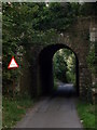
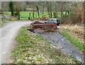
Road bridge under the B4251-Wattsville Gwent
The aged bridge under the B4251 in the Sirhowy Valley village of Wattsville Gwent. Borough of Caerphilly. Looking South, down the lane which connects Mynyddislwyn (292m) with The Sirhowy Country Park.
Image: © Stephen MARSDEN
Taken: 19 Sep 2009
0.05 miles
6
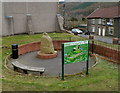
Sculpture, information board and bench, Wattsville
Set in a circular area on the north side of Islwyn Road.
The sculpture http://www.geograph.org.uk/photo/1910852 depicts a miner and the village of Wattsville.
The information board states that the village of Wattsville came into existence in the late 19th century and is named after Edmund Hannay Watts who formed the London and South Wales Coal Company in 1873.
The village was built to provide housing for the workers in the numerous collieries in the area including the Risca Mine, which was situated on the eastern edge of the village. This mine was 855 feet deep and was the first pit in South Wales to have electric lighting at the pit head and underground. An explosion at the colliery in 1880 caused 120 deaths, even though the mine was thought to be among the safest in the area.
The information board shows a map of the area and gives suggestions of what to see, such as the wildlife and fauna of the Sirhowy Valley Country Park, Full Moon Visitor Centre and the recently-restored Grade II listed Penllwyn Tramroad Bridge. The Welsh language side of the board is in view. The English language side is on the reverse.
The bench was a convenient location for lunchtime sandwiches and coffee to be consumed!
Image: © Jaggery
Taken: 16 Mar 2012
0.06 miles
7
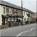
Wattsville National Club
Located at 116 Islwyn Road.
Image: © Jaggery
Taken: 26 May 2010
0.07 miles
8
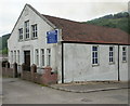
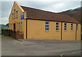
Bethel Church, Wattsville
Located on Duffryn Terrace. The church, founded in 1905, is a member of the Baptist Union of Great Britain.
The slightly darker grey in the top right corner is smoke http://www.geograph.org.uk/photo/1891097 from a hillside forest fire.
Update March 2012. The church has been painted a different colour. http://www.geograph.org.uk/photo/2852055
Image: © Jaggery
Taken: 26 May 2010
0.07 miles
9
Bethel Church, Wattsville
Located on Duffryn Terrace. The top three lines of the name board show
BETHEL
The church in the community
(Established 1905).
Here's http://www.geograph.org.uk/photo/1891094 how the church looked in May 2010.
Image: © Jaggery
Taken: 16 Mar 2012
0.07 miles
10
Nant Hafod-tudur enters a culvert, Wattsville
60 metres after emerging from a culvert http://www.geograph.org.uk/photo/2852146 the stream enters another one, to pass under a road. Nant Hafod-tudur resurfaces on the far side of the road and flows into the Sirhowy, about 200 metres away.
Image: © Jaggery
Taken: 16 Mar 2012
0.08 miles