IMAGES TAKEN NEAR TO
Cromwell Road, NEWPORT, NP11 6YF
Introduction
This page details the photographs taken nearby to Cromwell Road, NP11 6YF by members of the Geograph project.
The Geograph project started in 2005 with the aim of publishing, organising and preserving representative images for every square kilometre of Great Britain, Ireland and the Isle of Man.

There are currently over 7.5m images from over14,400 individuals and you can help contribute to the project by visiting https://www.geograph.org.uk
Image Map
Images are licensed for reuse under creativecommons.org/licenses/by-sa/2.0
Notes
- Clicking on the map will re-center to the selected point.
- The higher the marker number, the further away the image location is from the centre of the postcode.
Image Listing (107 Images Found)
Images are licensed for reuse under creativecommons.org/licenses/by-sa/2.0
Image
Details
Distance
1
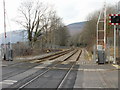
Railway lines heading northwest from Lime Kiln level crossing, Risca
The next station is this direction, on the Cardiff Central toEbbw Vale Parkway route, is Crosskeys, nearly 2 kilometres distant. Viewed from Lime Kiln level crossing. http://www.geograph.org.uk/photo/1759011
The view in the opposite direction. http://www.geograph.org.uk/photo/1759067
Image: © Jaggery
Taken: 11 Mar 2010
0.02 miles
2
Darran Road west of Lime Kiln level crossing, Risca
Looking towards the B4591 from the edge of this http://www.geograph.org.uk/photo/1759011 level crossing.
Image: © Jaggery
Taken: 11 Jan 2014
0.03 miles
3
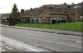
Derelict former Ty Darran care home, Risca
Viewed in January 2017. Metal sheeting cover windows and doors of the former care home which closed in 2010.
Image: © Jaggery
Taken: 10 Jan 2017
0.03 miles
4
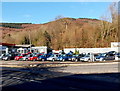
Philip Retter Car Sales in Risca
On the corner of the B4591 and Darran Road.
Image: © Jaggery
Taken: 11 Jan 2014
0.04 miles
5
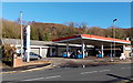
Esso filling station and shop, Risca
Viewed across the B4591 near the Darran Road junction.
Image: © Jaggery
Taken: 11 Jan 2014
0.04 miles
6
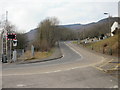
Darran Road, Risca
Darran Road heads away from Risca and a level crossing http://www.geograph.org.uk/photo/1759011 over the Cardiff Central to Ebbw Vale Parkway railway lines.
Image: © Jaggery
Taken: 11 Mar 2010
0.04 miles
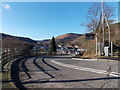
7
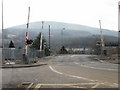
Level crossing on a hairpin bend, Risca
Lime Kiln level crossing cuts through the middle of a hairpin bend in Darran Road's descent towards the B4591 (the western end of St Mary Street and the eastern end of Cromwell Road). The railway lines are between Risca & Pontymister station and Crosskeys station on the Cardiff Central to Ebbw Vale Parkway route.
http://www.geograph.org.uk/photo/1759000 to the northern half of the hairpin bend.
http://www.geograph.org.uk/photo/1759121 to the view from the southern approach.
Formerly, there was a signal box next to the level crossing to control the points at the location nearby where two tracks merged into one.
Image: © Jaggery
Taken: 11 Mar 2010
0.04 miles
8
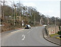
Darran Road climbs towards Lime Kiln level crossing, Risca
Darran Road heads away from Cromwell Road and St Mary Street, towards a level crossing, http://www.geograph.org.uk/photo/1759011 which passes through a hairpin bend in the road.
Image: © Jaggery
Taken: 11 Mar 2010
0.04 miles
9
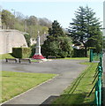
Risca War Memorial
Located between St Mary Street (B4591) and Darran Road.
Image: © Jaggery
Taken: 10 Apr 2011
0.04 miles
10
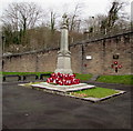
Risca War Memorial
Located in a fenced area alongside St Mary Street, below Darran Road.
Image: © Jaggery
Taken: 10 Jan 2017
0.04 miles