IMAGES TAKEN NEAR TO
Chiltern Close, NEWPORT, NP11 6QX
Introduction
This page details the photographs taken nearby to Chiltern Close, NP11 6QX by members of the Geograph project.
The Geograph project started in 2005 with the aim of publishing, organising and preserving representative images for every square kilometre of Great Britain, Ireland and the Isle of Man.

There are currently over 7.5m images from over14,400 individuals and you can help contribute to the project by visiting https://www.geograph.org.uk
Image Map
Images are licensed for reuse under creativecommons.org/licenses/by-sa/2.0
Notes
- Clicking on the map will re-center to the selected point.
- The higher the marker number, the further away the image location is from the centre of the postcode.
Image Listing (51 Images Found)
Images are licensed for reuse under creativecommons.org/licenses/by-sa/2.0
Image
Details
Distance
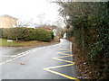
1
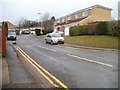
Mountside, Risca
Mountside is a cul-de-sac on the north side of Pontymason Lane.
Image: © Jaggery
Taken: 14 Jan 2011
0.03 miles
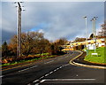
2

Ordnance Survey Cut Mark
This OS cut mark can be found on the wall north side of Pontymason Lane. It marks a point 140.080m above mean sea level.
Image: © Adrian Dust
Taken: 11 May 2019
0.04 miles
3
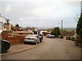
Malvern Close, Risca
Viewed from the corner of Cotswold Way. http://www.geograph.org.uk/photo/2232188
Image: © Jaggery
Taken: 14 Jan 2011
0.04 miles
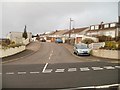
4
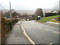
Cotswold Way bus stops, Risca
One bus stop with a shelter, one without, on Cotswold Way between the turnings for Mendip Close and Chiltern Close.
Image: © Jaggery
Taken: 14 Jan 2011
0.05 miles
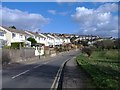
5
Pentland Close, Risca
Viewed from the corner of Cotswold Way. Because of the steepness of the land in this area, the houses on the south side of the close are set about two metres below road level.
Image: © Jaggery
Taken: 14 Jan 2011
0.05 miles
6
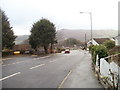
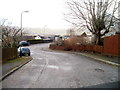
Risca : Cotswold Way passes Malvern Close
Cotswold Way descends towards Elm Drive past the turning for Malvern Close. http://www.geograph.org.uk/photo/2232192
Image: © Jaggery
Taken: 14 Jan 2011
0.05 miles
7
Mendip Close, Risca
Viewed across Cotswold Way.
Image: © Jaggery
Taken: 14 Jan 2011
0.05 miles
9
Pontymason Lane NW of a school entrance road, Risca
Viewed from the corner of this http://www.geograph.org.uk/photo/4242524 road.
Image: © Jaggery
Taken: 22 Jan 2014
0.08 miles
10
Lane from Pontymason Lane to Mountain Road, Risca
An unnamed lane heads north towards Mountain Road, past the left turn into Mountside. http://www.geograph.org.uk/photo/2232280
Image: © Jaggery
Taken: 14 Jan 2011
0.09 miles