IMAGES TAKEN NEAR TO
Lower Wyndham Terrace, NEWPORT, NP11 6QR
Introduction
This page details the photographs taken nearby to Lower Wyndham Terrace, NP11 6QR by members of the Geograph project.
The Geograph project started in 2005 with the aim of publishing, organising and preserving representative images for every square kilometre of Great Britain, Ireland and the Isle of Man.

There are currently over 7.5m images from over14,400 individuals and you can help contribute to the project by visiting https://www.geograph.org.uk
Image Map
Images are licensed for reuse under creativecommons.org/licenses/by-sa/2.0
Notes
- Clicking on the map will re-center to the selected point.
- The higher the marker number, the further away the image location is from the centre of the postcode.
Image Listing (94 Images Found)
Images are licensed for reuse under creativecommons.org/licenses/by-sa/2.0
Image
Details
Distance
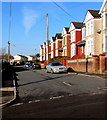
1
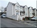
East side of Wyndham Terrace, Risca
Houses viewed across Lower Wyndham Terrace. The street name sign shows
WYNDHAM TCE.
NOS 11-18
LEADING TO MANOR CLOSE
NOS 4 & 6.
Image: © Jaggery
Taken: 17 Feb 2011
0.02 miles
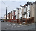
2
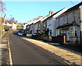
Lower Wyndham Terrace semis, Risca
Semi-detached houses on the east side of Lower Wyndham Terrace,
on the ascent towards the Ty Sign area of Risca.
Image: © Jaggery
Taken: 22 Nov 2018
0.03 miles
3
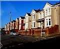
Sunny side of Wyndham Terrace, Risca
Houses on the north side of Wyndham Terrace viewed across Lower Wyndham Terrace on November 22nd 2018.
Image: © Jaggery
Taken: 22 Nov 2018
0.03 miles
4
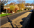
Two-tone road surface, Lower Wyndham Terrace, Risca
On the ascent towards the Ty Sign area of Risca.
Image: © Jaggery
Taken: 22 Nov 2018
0.03 miles
5
West along Wyndham Terrace, Risca
From Lower Wyndham Terrace along Wyndham Terrace towards Wood View Crescent and Wood View Road.
Image: © Jaggery
Taken: 22 Nov 2018
0.04 miles
6
West side of Wyndham Terrace, Risca
Viewed across Lower Wyndham Terrace.
Image: © Jaggery
Taken: 17 Feb 2011
0.04 miles
7
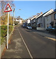
Warning sign - elderly people, Lower Wyndham Terrace, Risca
On the left here. https://www.geograph.org.uk/photo/5984825
Image: © Jaggery
Taken: 22 Nov 2018
0.04 miles
8
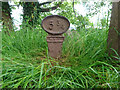
Milestone, Lower Wyndham Terrace
On the MonBrec canal Crumlin branch. Milepost / mile peg dates from the days of the Monmouth Canal Company. Grade II listed see CADW https://cadwpublic-api.azurewebsites.net/reports/listedbuilding/FullReport?lang=&id=87787 . Long view facing Lower Wyndham Terrace https://www.geograph.org.uk/photo/3626076
Inscription: 5 ¾
Milestone Society National ID: CRU-05¾
Image: © Mr Red
Taken: 10 Jun 2021
0.05 miles
9
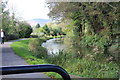
Monmouthshire & Brecon Canal north west of Thistle Way
Disused Crumlin Arm of the canal and towpath (cycle route); the canal is in a culvert under Thistle Way.
Image: © M J Roscoe
Taken: 20 Oct 2017
0.06 miles
10
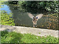
We have lift-off!
A duck launching himself into the Monmouthshire and Brecon canal.
Image: © Alan Hughes
Taken: 15 Jul 2021
0.06 miles