IMAGES TAKEN NEAR TO
Ebbw Street, NEWPORT, NP11 6DJ
Introduction
This page details the photographs taken nearby to Ebbw Street, NP11 6DJ by members of the Geograph project.
The Geograph project started in 2005 with the aim of publishing, organising and preserving representative images for every square kilometre of Great Britain, Ireland and the Isle of Man.

There are currently over 7.5m images from over14,400 individuals and you can help contribute to the project by visiting https://www.geograph.org.uk
Image Map
Images are licensed for reuse under creativecommons.org/licenses/by-sa/2.0
Notes
- Clicking on the map will re-center to the selected point.
- The higher the marker number, the further away the image location is from the centre of the postcode.
Image Listing (261 Images Found)
Images are licensed for reuse under creativecommons.org/licenses/by-sa/2.0
Image
Details
Distance
1
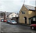
Coach House Workshop, Phillip Street, Risca
Viewed from the corner of Ebbw Street. Coach House Workshop is the Risca office of MVRRS (Mountain View Residential and Respite Services Ltd). Their Newport Centre is in Emlyn Walk, Kingsway.
Image: © Jaggery
Taken: 11 Apr 2013
0.01 miles
2
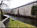
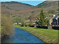
Ebbw Street flood defence wall, Risca
Viewed from the river bridge seen here. http://www.geograph.org.uk/photo/3408902
The 200 metre long flood defence wall is on the east bank of the River Ebbw.
Image: © Jaggery
Taken: 11 Apr 2013
0.02 miles
3
River Ebbw downstream from Ebbw Street Risca
Viewed from the northern edge of Ebbw Street and the SW edge of a recreation ground. The Ebbw here flows between Ebbw Street on the left and the high wall which is part of the structure carrying an elevated section of the A467.
Image: © Jaggery
Taken: 11 Apr 2013
0.03 miles
4
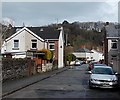
Phillip Street, Risca
A view east from the Ebbw Street end looking towards Bridge Street.
Image: © Jaggery
Taken: 11 Apr 2013
0.03 miles
5
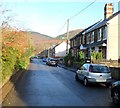
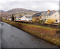
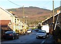
Ebbw Street, Risca
Looking north from the Danygraig Road end. All the houses are on the east side of the street. The bushes on the left side are on the bank of the River Ebbw.
Image: © Jaggery
Taken: 30 Nov 2011
0.04 miles
6
River Ebbw, Risca
The Risca bypass (A467) http://www.geograph.org.uk/photo/4845672 is above and to the left of the river at this point.
Image: © Robin Drayton
Taken: 24 Feb 2016
0.04 miles
7
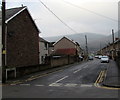
North along Bridge Street, Risca
Viewed across Danygraig Road from the corner of Gwendoline Road,
looking along Bridge Street towards Phillip Street.
Image: © Jaggery
Taken: 20 Dec 2016
0.04 miles
8
Northern end of Ebbw Street, Risca
Viewed from the SW corner of a recreation ground. Risca Sea Cadets TS Twmbarlwm is nearby. http://www.geograph.org.uk/photo/3407649
The high wall on the right is the River Ebbw edge of the elevated A467.
Image: © Jaggery
Taken: 11 Apr 2013
0.04 miles
9
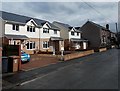
New and old in Ebbw Street, Risca
The recently-built white houses are many decades newer than the other houses in the street.
Image: © Jaggery
Taken: 11 Apr 2013
0.05 miles
10
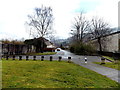
Bridge Street, Risca
Looking north along Bridge Street from the Danygraig Road side. Beyond the Phillip Street intersection ahead, the northern end of Bridge Street is at the edge of a recreation ground.
Image: © Jaggery
Taken: 30 Nov 2011
0.05 miles