1
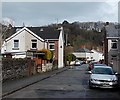
Phillip Street, Risca
A view east from the Ebbw Street end looking towards Bridge Street.
Image: © Jaggery
Taken: 11 Apr 2013
0.01 miles
2
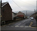
North along Bridge Street, Risca
Viewed across Danygraig Road from the corner of Gwendoline Road,
looking along Bridge Street towards Phillip Street.
Image: © Jaggery
Taken: 20 Dec 2016
0.01 miles
3
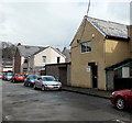
Coach House Workshop, Phillip Street, Risca
Viewed from the corner of Ebbw Street. Coach House Workshop is the Risca office of MVRRS (Mountain View Residential and Respite Services Ltd). Their Newport Centre is in Emlyn Walk, Kingsway.
Image: © Jaggery
Taken: 11 Apr 2013
0.03 miles
4
New and old in Ebbw Street, Risca
The recently-built white houses are many decades newer than the other houses in the street.
Image: © Jaggery
Taken: 11 Apr 2013
0.04 miles
5
Ebbw Street flood defence wall, Risca
Viewed from the river bridge seen here. http://www.geograph.org.uk/photo/3408902
The 200 metre long flood defence wall is on the east bank of the River Ebbw.
Image: © Jaggery
Taken: 11 Apr 2013
0.05 miles
6
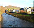
River Ebbw downstream from Ebbw Street Risca
Viewed from the northern edge of Ebbw Street and the SW edge of a recreation ground. The Ebbw here flows between Ebbw Street on the left and the high wall which is part of the structure carrying an elevated section of the A467.
Image: © Jaggery
Taken: 11 Apr 2013
0.05 miles
7
River Ebbw, Risca
The Risca bypass (A467) http://www.geograph.org.uk/photo/4845672 is above and to the left of the river at this point.
Image: © Robin Drayton
Taken: 24 Feb 2016
0.05 miles
8
Bridge Street, Risca
Looking north along Bridge Street from the Danygraig Road side. Beyond the Phillip Street intersection ahead, the northern end of Bridge Street is at the edge of a recreation ground.
Image: © Jaggery
Taken: 30 Nov 2011
0.06 miles
9
Risca : River Ebbw flows towards the Danygraig Road bridge
Viewed from the bridge carrying Danygraig Road over the river. On the right is Ebbw Street. http://www.geograph.org.uk/photo/2715192
http://www.geograph.org.uk/photo/2715217 to a view from the opposite side.
Image: © Jaggery
Taken: 30 Nov 2011
0.06 miles
10
Ebbw Street Risca viewed across the River Ebbw
Viewed from Danygraig Road on the west bank.
Image: © Jaggery
Taken: 30 Nov 2011
0.06 miles


