IMAGES TAKEN NEAR TO
Maryland Road, NEWPORT, NP11 6BB
Introduction
This page details the photographs taken nearby to Maryland Road, NP11 6BB by members of the Geograph project.
The Geograph project started in 2005 with the aim of publishing, organising and preserving representative images for every square kilometre of Great Britain, Ireland and the Isle of Man.

There are currently over 7.5m images from over14,400 individuals and you can help contribute to the project by visiting https://www.geograph.org.uk
Image Map
Images are licensed for reuse under creativecommons.org/licenses/by-sa/2.0
Notes
- Clicking on the map will re-center to the selected point.
- The higher the marker number, the further away the image location is from the centre of the postcode.
Image Listing (180 Images Found)
Images are licensed for reuse under creativecommons.org/licenses/by-sa/2.0
Image
Details
Distance
1
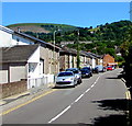
Maryland Road, Pontymister
North along Maryland Road towards Risca & Pontymister railway station.
Image: © Jaggery
Taken: 22 Jun 2018
0.01 miles
2
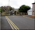
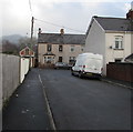
Turning area at the northern end of Llanarth Square, Risca
Viewed in December 2016. Double yellow lines on both sides indicate no parking at any time. Llanarth Square must have had a different configuration when it was named. Now it is a straight dead street.
Image: © Jaggery
Taken: 20 Dec 2016
0.02 miles
3
Llanarth Square, Risca
Dead end street on the north side of Commercial Street.
The reason for this straight street being named a Square is not apparent in 2016.
Image: © Jaggery
Taken: 20 Dec 2016
0.02 miles
4
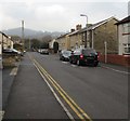
North along Maryland Road, Pontymister
From Commercial Street along Maryland Road towards the main entrance http://www.geograph.org.uk/photo/1756313 to Risca & Pontymister railway station.
Image: © Jaggery
Taken: 20 Dec 2016
0.03 miles
5
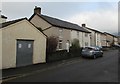
West side of Llanarth Square, Risca
Viewed from the corner of Commercial Street in December 2016.
On the left, metal sheeting protects a side entrance into the derelict former Rolling Mill pub http://www.geograph.org.uk/photo/5231932
Notices on the sheeting state Warning - this property is alarmed.
Do not enter without a PID key as this will result in security officers attending the site.
Image: © Jaggery
Taken: 20 Dec 2016
0.04 miles
6
Towards a bend in Trafalgar Street, Risca
The street turns through about 90 degrees ahead, from heading NNW to heading ESE.
Image: © Jaggery
Taken: 20 Dec 2016
0.06 miles
7
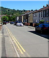
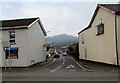
Llanarth Square, Pontymister
Looking north from near the corner of the B4591 Commercial Street.
Image: © Jaggery
Taken: 22 Jun 2018
0.06 miles
8
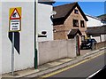
Warning sign - Disabled people, Maryland Road, Pontymister
Located here https://www.geograph.org.uk/photo/5232028 facing the B4591 Commercial Street. The text is also in Welsh.
This triangular sign is most often used to warn of elderly people, such as here https://www.geograph.org.uk/photo/5196683 in Droitwich.
Image: © Jaggery
Taken: 22 Jun 2018
0.06 miles

10
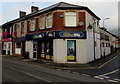
William Hill betting shop on a Pontymister corner
On the corner of Commercial Street and Clyde Street.
Image: © Jaggery
Taken: 20 Dec 2016
0.06 miles