IMAGES TAKEN NEAR TO
Maple Terrace, NEWPORT, NP11 5JF
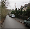
Introduction
This page details the photographs taken nearby to Maple Terrace, NP11 5JF by members of the Geograph project.
The Geograph project started in 2005 with the aim of publishing, organising and preserving representative images for every square kilometre of Great Britain, Ireland and the Isle of Man.

There are currently over 7.5m images from over14,400 individuals and you can help contribute to the project by visiting https://www.geograph.org.uk
Image Map
Images are licensed for reuse under creativecommons.org/licenses/by-sa/2.0
Notes
- Clicking on the map will re-center to the selected point.
- The higher the marker number, the further away the image location is from the centre of the postcode.
Image Listing (110 Images Found)
Images are licensed for reuse under creativecommons.org/licenses/by-sa/2.0
Image
Details
Distance
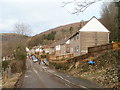
1
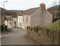
Sycamore Terrace, Abercarn
Houses at the southern end of Sycamore Terrace, viewed from Cemetery Road.
Image: © Jaggery
Taken: 24 Jan 2011
0.01 miles
2
Abercarn : Cemetery Road climbs away from Sycamore Terrace
On the right is the edge of a wood, Coed Ffordd-fawr.
Image: © Jaggery
Taken: 24 Jan 2011
0.01 miles
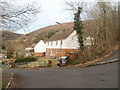
3
Maple Terrace, Abercarn
Maple Terrace houses viewed from the B4591.
Image: © Jaggery
Taken: 23 Jan 2011
0.05 miles
4
Acacia Terrace, Abercarn
The view from Cemetery Road down Sycamore Terrace (which turns to the right next to the nearest house) towards Acacia Terrace.
Image: © Jaggery
Taken: 24 Jan 2011
0.06 miles
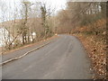
5
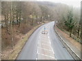
A467 Abercarn
Viewed from a footbridge. http://www.geograph.org.uk/photo/2295819 The A467 heads south, near The B4591 on the left, at a slightly higher level.
Image: © Jaggery
Taken: 23 Jan 2011
0.07 miles
6
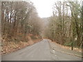
Abercarn : Cemetery Road descends past Sycamore Terrace
Viewed from the Sycamore Terrace turning. http://www.geograph.org.uk/photo/2286355 Cemetery Road descends towards the B4591 along the edge of a wood (on the left) named Coed Ffordd-fawr.
Image: © Jaggery
Taken: 24 Jan 2011
0.09 miles
7
Laburnum Terrace, Abercarn
Viewed from the Cemetery Road end.
Image: © Jaggery
Taken: 24 Jan 2011
0.09 miles
8
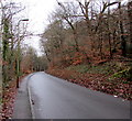
Up Cemetery Road, Abercarn
From the B4591, Cemetery Road ascends towards the entrance http://www.geograph.org.uk/photo/2286446 to Abercarn Cemetery.
Image: © Jaggery
Taken: 7 Jan 2017
0.10 miles
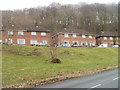
9
Penrhiw Terrace, Llanfach, Abercarn
The houses are opposite a wood named Coed Ffordd-fawr.
Image: © Jaggery
Taken: 7 Jan 2017
0.10 miles
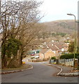
10
Top end of Hill Street, Abercarn
A path http://www.geograph.org.uk/photo/2286549 from Abercarn cemetery reaches houses at the top (east) end of Hill Street.
Image: © Jaggery
Taken: 24 Jan 2011
0.12 miles