IMAGES TAKEN NEAR TO
Crumlin Square, NEWPORT, NP11 4QD
Introduction
This page details the photographs taken nearby to Crumlin Square, NP11 4QD by members of the Geograph project.
The Geograph project started in 2005 with the aim of publishing, organising and preserving representative images for every square kilometre of Great Britain, Ireland and the Isle of Man.

There are currently over 7.5m images from over14,400 individuals and you can help contribute to the project by visiting https://www.geograph.org.uk
Image Map
Images are licensed for reuse under creativecommons.org/licenses/by-sa/2.0
Notes
- Clicking on the map will re-center to the selected point.
- The higher the marker number, the further away the image location is from the centre of the postcode.
Image Listing (138 Images Found)
Images are licensed for reuse under creativecommons.org/licenses/by-sa/2.0
Image
Details
Distance
1
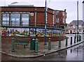
Mural in Crumlin
Even on a wet Friday, this mural in the centre of Crumlin brightens up the place. It depicts the history of the town and the Ebbw Valley, and along the top shows the famous Crumlin railway viaduct.
Image: © Graham Horn
Taken: 28 Dec 2007
0.01 miles


4
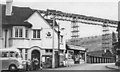
Crumlin Viaduct from A467 road bridge at Low Level station
View northward, towards Crumlin (High Level), Aberdare and Neath left, Pontypool Road right: ex-GWR Pontypool Road - Neath line. (Underneath is the Newport - Ebbw Vale/Brynmawr (Western Valleys) line; see Image The westbound empties 'perilously' high up on the 200-foot viaduct (demolished 1967), are headed by a 28XX 2-8-0 exemplifying the heavy coal traffic between the Welsh Valleys and England by this route, which however was closed on 15/06/1964.
Image: © Ben Brooksbank
Taken: 11 May 1957
0.02 miles
5
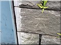
Ordnance Survey Cut Mark
This OS cut mark can be found on the SE parapet of the Railway Bridge. It marks a point 124.776m above mean sea level.
Image: © Adrian Dust
Taken: 11 May 2019
0.02 miles
6
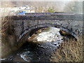
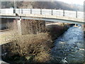
Stone bridge across the Ebbw, Crumlin
The bridge carries a footpath from the A467 on the left, across the River Ebbw, to Crumlin Square.
Image: © Jaggery
Taken: 17 Feb 2011
0.02 miles
7
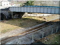
Bridge over a railway line, Crumlin
The bridge carries a footpath (from the A467 to Crumlin Square) over the single-track Ebbw Valley line, between Newbridge and Llanhilleth stations. On the left, a stone bridge http://www.geograph.org.uk/photo/2713152 conveys the footpath over the River Ebbw.
Image: © Jaggery
Taken: 17 Feb 2011
0.02 miles
8
Eastern side of Kendon Road bridge, Crumlin
Viewed from a footbridge. http://www.geograph.org.uk/photo/2713163
The bridge carries the B4251 (here named Kendon Road) over the River Ebbw and a railway line. http://www.geograph.org.uk/photo/2751346
Image: © Jaggery
Taken: 17 Feb 2011
0.02 miles
9

Eastern end of Kendon Road, Crumlin
The B4251, here named Kendon Road, approaches a bridge leading to the A467 junction. Turn left ahead for Brynmawr or Ebbw Vale, right for Newport or Pontypool.
The nearer left turn leads to the remains of Crumlin Navigation Colliery buildings.
Image: © Jaggery
Taken: 17 Feb 2011
0.02 miles
10

Eddie Stobart lorry Lauren Louise on the A467, Crumlin
The Volvo lorry passes the B4251 Kendon Road junction. Most Eddie Stobart lorries have female names. This one is named Lauren Louise.
Image: © Jaggery
Taken: 17 Feb 2011
0.02 miles