IMAGES TAKEN NEAR TO
Royal Crescent, NEWPORT, NP11 3DZ
Introduction
This page details the photographs taken nearby to Royal Crescent, NP11 3DZ by members of the Geograph project.
The Geograph project started in 2005 with the aim of publishing, organising and preserving representative images for every square kilometre of Great Britain, Ireland and the Isle of Man.

There are currently over 7.5m images from over14,400 individuals and you can help contribute to the project by visiting https://www.geograph.org.uk
Image Map
Images are licensed for reuse under creativecommons.org/licenses/by-sa/2.0
Notes
- Clicking on the map will re-center to the selected point.
- The higher the marker number, the further away the image location is from the centre of the postcode.
Image Listing (28 Images Found)
Images are licensed for reuse under creativecommons.org/licenses/by-sa/2.0
Image
Details
Distance
2
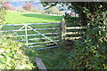
Stile, Ebbw Valley Walk, near Treowen
Partly overgrown stile and plank footbridge on a little used section of the field footpath.
Image: © M J Roscoe
Taken: 13 Oct 2016
0.15 miles
3
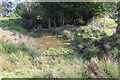
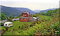
Farm pond, Tir-hunt
Muddy pond at junction of three fields and farmhouse garden. The pond is next to the Ebbw Valley Walk Image
Image: © M J Roscoe
Taken: 13 Oct 2016
0.16 miles
4
Ebbw Valley Walk towards Tir hunt
The line of the path is not apparent on the ground as it crosses a field with many rushes towards a stile just visible to the right of a heap of manure. The disused farmhouse is partly through the trees. The coniferous plantations are above Pantside on the far side of the Ebbw Valley.
Image: © M J Roscoe
Taken: 13 Oct 2016
0.18 miles
5
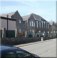
Crumlin High Level Primary School
Viewed along Commercial Road. The school, for children aged 3 to 11, has about 230 pupils enrolled.
Image: © Jaggery
Taken: 17 Feb 2011
0.18 miles
6
Site of Crumlin (High Level) station, 1990
View southward down the Ebbw Valley, towards Aberdare and Neath on the ex-GWR Pontypool Road - Aberdare - Neath line. The station and route closed on 15/6/64, but the celebrated Crumlin Viaduct, which is some way behind the camera, was not dismantled until 1967.
Image: © Ben Brooksbank
Taken: 19 May 1990
0.18 miles
7
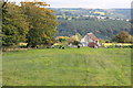
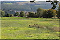
Cattle & old building, Tir-hunt
The cattle are on the northern side of the wet field in Image The coniferous plantation is on the far side of the Ebbw Valley.
Image: © M J Roscoe
Taken: 13 Oct 2016
0.18 miles
9
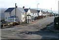
Treowen Road, Treowen
View from Parry Terrace.
Image: © Jaggery
Taken: 17 Feb 2011
0.19 miles
10
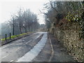
Mining School Hill, Crumlin
The road climbs away from Main Street, heading towards the Crumlin Rathbone centre, which opened in 1976. The centre occupies the former mining school building.
Image: © Jaggery
Taken: 17 Feb 2011
0.20 miles