IMAGES TAKEN NEAR TO
Treowen Road, NEWPORT, NP11 3DP
Introduction
This page details the photographs taken nearby to Treowen Road, NP11 3DP by members of the Geograph project.
The Geograph project started in 2005 with the aim of publishing, organising and preserving representative images for every square kilometre of Great Britain, Ireland and the Isle of Man.

There are currently over 7.5m images from over14,400 individuals and you can help contribute to the project by visiting https://www.geograph.org.uk
Image Map
Images are licensed for reuse under creativecommons.org/licenses/by-sa/2.0
Notes
- Clicking on the map will re-center to the selected point.
- The higher the marker number, the further away the image location is from the centre of the postcode.
Image Listing (58 Images Found)
Images are licensed for reuse under creativecommons.org/licenses/by-sa/2.0
Image
Details
Distance
1
Site of Crumlin (High Level) station, 1990
View southward down the Ebbw Valley, towards Aberdare and Neath on the ex-GWR Pontypool Road - Aberdare - Neath line. The station and route closed on 15/6/64, but the celebrated Crumlin Viaduct, which is some way behind the camera, was not dismantled until 1967.
Image: © Ben Brooksbank
Taken: 19 May 1990
0.07 miles
2
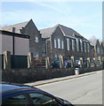
Crumlin High Level Primary School
Viewed along Commercial Road. The school, for children aged 3 to 11, has about 230 pupils enrolled.
Image: © Jaggery
Taken: 17 Feb 2011
0.08 miles
3
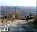
Hillside descends from Treowen to Crumlin
Viewed from the edge of Parry Terrace, http://www.geograph.org.uk/photo/2299160
The road is named Hillside. A sign shows a 17% (1 in 6) slope and tells drivers to use low gear now.
The sign at the foot of the hill http://www.geograph.org.uk/photo/2297560, about 450 metres away, shows 25% (1 in 4).
Image: © Jaggery
Taken: 17 Feb 2011
0.10 miles
4

Year stone, The Bridgend Inn, Crumlin
The year 1820 is inscribed in stone on the Inn. http://www.geograph.org.uk/photo/2299107 This predates by several decades the construction of the famous Crumlin Viaduct depicted on its inn sign. http://www.geograph.org.uk/photo/2299113
Image: © Jaggery
Taken: 17 Feb 2011
0.10 miles
5
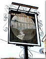
Crumlin Viaduct depicted in The Bridgend Inn sign
The Inn's http://www.geograph.org.uk/photo/2299107 sign depicts the Crumlin Viaduct, which opened in 1857 and closed in 1964. At 200 feet high at the highest point above the valley floor, and 1650 feet long (two spans, 1066 feet and 584 feet), it was the highest railway viaduct in Great Britain throughout its working existence. It was built by the contractor T. W. Kennard. The pub is on the corner of Kennard Terrace.
Image: © Jaggery
Taken: 17 Feb 2011
0.10 miles
6
The Bridgend Inn, Crumlin
Inn dating from 1820, http://www.geograph.org.uk/photo/2299116 located on the corner of Kennard Terrace and Hillside.
Image: © Jaggery
Taken: 17 Feb 2011
0.10 miles
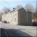
7
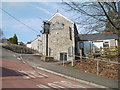
Side view of The Bridgend Inn, Crumlin
Viewed across Hillside. The inn, dating from 1820, http://www.geograph.org.uk/photo/2299116 is on the corner of Kennard Terrace.
Image: © Jaggery
Taken: 17 Feb 2011
0.10 miles
9
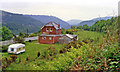
Treowen Road, Treowen
View from Parry Terrace.
Image: © Jaggery
Taken: 17 Feb 2011
0.11 miles
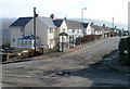
10
Hillside houses, Crumlin
Houses on the north side of a street named Hillside, http://www.geograph.org.uk/photo/2297560 viewed from near the corner of Whitethorne Street.
Image: © Jaggery
Taken: 17 Feb 2011
0.12 miles