IMAGES TAKEN NEAR TO
Nellive Park, NEWPORT, NP10 8SE
Introduction
This page details the photographs taken nearby to Nellive Park, NP10 8SE by members of the Geograph project.
The Geograph project started in 2005 with the aim of publishing, organising and preserving representative images for every square kilometre of Great Britain, Ireland and the Isle of Man.

There are currently over 7.5m images from over14,400 individuals and you can help contribute to the project by visiting https://www.geograph.org.uk
Image Map
Images are licensed for reuse under creativecommons.org/licenses/by-sa/2.0
Notes
- Clicking on the map will re-center to the selected point.
- The higher the marker number, the further away the image location is from the centre of the postcode.
Image Listing (73 Images Found)
Images are licensed for reuse under creativecommons.org/licenses/by-sa/2.0
Image
Details
Distance
1
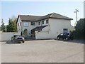
Chapel Guest House, St Brides
A modernised guest house located in the former Rehoboth Baptist chapel house (1828).
Image: © Jaggery
Taken: 22 Apr 2010
0.02 miles
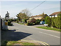
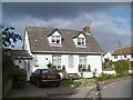
2

Neville Park, St Brides
The entrance from the B4239 to Neville Park, a G-shaped residential street.
Image: © Jaggery
Taken: 22 Apr 2010
0.02 miles
3
Church Road, St Brides
The view from the corner of the B4239.
On the left is the turning for the Church House Inn http://www.geograph.org.uk/photo/1859836 and Chapel Guest House http://www.geograph.org.uk/photo/1860073 ;
on the right, the white house is part of Bridesvale Gardens. http://www.geograph.org.uk/photo/1859789
Image: © Jaggery
Taken: 22 Apr 2010
0.04 miles
4
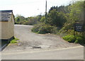
Church House Inn St Brides - overflow car park
Parking should rarely be a problem for customers of the Church House Inn - there is an overflow car park as well as parking space in front of the Inn. http://www.geograph.org.uk/photo/1859836
Image: © Jaggery
Taken: 22 Apr 2010
0.04 miles
5
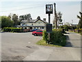
Church House Inn, St Brides
Parking should rarely be a problem here - as well as the car park in front of the inn, there's an overflow car park nearby. http://www.geograph.org.uk/photo/1859845
Image: © Jaggery
Taken: 22 Apr 2010
0.04 miles
6
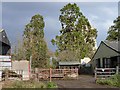
Church Farm, St Brides Wentlooge
The tower of St Bridget's Church is just visible behind a tree.
Image: © Robin Drayton
Taken: 9 Nov 2007
0.06 miles
7
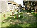
St Bridget's churchyard, St Brides
The small churchyard is on the south side of the church. http://www.geograph.org.uk/photo/1860041
Image: © Jaggery
Taken: 22 Apr 2010
0.07 miles
8
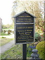
Church board, St Brides
The entrance to the Church of St Bridget, http://www.geograph.org.uk/photo/1860041 located at the north end of St Brides.
Image: © Jaggery
Taken: 22 Apr 2010
0.07 miles
9
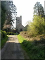
Approach path to the Church of St Bridget, St Brides
The church, after which the village is named, is in a secluded location at the north end of the village.
It is dedicated to St Bridget of Kildare, Ireland who lived in the 5th and early 6th century. Variant spellings of her name include Brigid and Bride.
Image: © Jaggery
Taken: 22 Apr 2010
0.07 miles
10
Rehoboth Cottage, St Brides Wentlooge
Built in 1828 and formerly Rehoboth Baptist Chapel. Memorials in the graveyard can be seen in the right.
Image: © Robin Drayton
Taken: 9 Nov 2007
0.07 miles