IMAGES TAKEN NEAR TO
Fort View, NEWPORT, NP10 8PF
Introduction
This page details the photographs taken nearby to Fort View, NP10 8PF by members of the Geograph project.
The Geograph project started in 2005 with the aim of publishing, organising and preserving representative images for every square kilometre of Great Britain, Ireland and the Isle of Man.

There are currently over 7.5m images from over14,400 individuals and you can help contribute to the project by visiting https://www.geograph.org.uk
Image Map
Images are licensed for reuse under creativecommons.org/licenses/by-sa/2.0
Notes
- Clicking on the map will re-center to the selected point.
- The higher the marker number, the further away the image location is from the centre of the postcode.
Image Listing (119 Images Found)
Images are licensed for reuse under creativecommons.org/licenses/by-sa/2.0
Image
Details
Distance
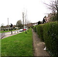
1
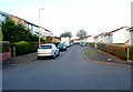
SW end of Fort View, Bassaleg
Looking in the direction of Laurel Road. A play park http://www.geograph.org.uk/photo/3199492 is a few metres behind the camera.
Image: © Jaggery
Taken: 27 Oct 2012
0.01 miles
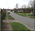
2
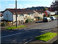
Fort View houses, Bassaleg
Steel-framed houses in Fort View, viewed from the Laurel Road end.
The Fort in question is this one. http://www.geograph.org.uk/photo/619433
Image: © Jaggery
Taken: 27 Oct 2012
0.02 miles
4
Highfield Play Park, Bassaleg
Access to the play park is from the SW end of Fort View. http://www.geograph.org.uk/photo/3199546
The play park is provided and maintained by Graig Community Council for children of the Graig area.
Image: © Jaggery
Taken: 27 Oct 2012
0.05 miles
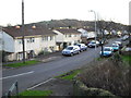
5
Slightly elevated pavement on the north side of Caerphilly Road, Bassaleg
The pavement here is about a metre above the A468 roadway.
Image: © Jaggery
Taken: 20 Mar 2019
0.08 miles
6
Up Laurel Road, Bassaleg
Laurel Road ascends away from the camera near the corner of St Basil's Crescent.
Image: © Jaggery
Taken: 19 Mar 2019
0.09 miles
7
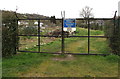
Allotments entrance gates, Bassaleg
Locked gates on the south side of Caerphilly Road in the northwest corner of these https://www.geograph.org.uk/photo/2771203 allotments.
The Graig Community Council notice shows PRIVATE ALLOTMENT HOLDERS ONLY.
A caution notice states that anti-climb paint is on the gates.
Image: © Jaggery
Taken: 20 Mar 2019
0.09 miles
8
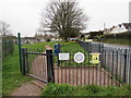
Cowshed Lane Playground entrance gate, Bassaleg
The notice near the gate states that Cowshed Lane Playground is for children between the ages of 11 and 15.
Image: © Jaggery
Taken: 20 Mar 2019
0.09 miles
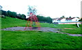
9
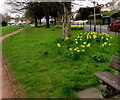
Daffodils in Cowshed Lane Playground, Bassaleg
Viewed on March 20th 2019.
Image: © Jaggery
Taken: 20 Mar 2019
0.09 miles
10
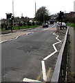
Pelican crossing, Caerphilly Road, Bassaleg
Across the A468 Caerphilly Road. Chambers Dictionary states that pelican in this context is adapted from pedestrian light controlled crossing.
Image: © Jaggery
Taken: 19 Mar 2019
0.10 miles