IMAGES TAKEN NEAR TO
Garth Close, NEWPORT, NP10 8NX
Introduction
This page details the photographs taken nearby to Garth Close, NP10 8NX by members of the Geograph project.
The Geograph project started in 2005 with the aim of publishing, organising and preserving representative images for every square kilometre of Great Britain, Ireland and the Isle of Man.

There are currently over 7.5m images from over14,400 individuals and you can help contribute to the project by visiting https://www.geograph.org.uk
Image Map
Images are licensed for reuse under creativecommons.org/licenses/by-sa/2.0
Notes
- Clicking on the map will re-center to the selected point.
- The higher the marker number, the further away the image location is from the centre of the postcode.
Image Listing (92 Images Found)
Images are licensed for reuse under creativecommons.org/licenses/by-sa/2.0
Image
Details
Distance
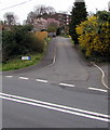
1
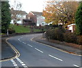
Bend in Laurel Road, Bassaleg
Laurel Road climbs away from crossroads at the Garth Close and Duffryn Close junctions.
Image: © Jaggery
Taken: 27 Oct 2012
0.08 miles
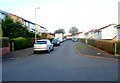
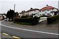
2
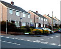
Duffryn Close, Bassaleg
Houses on the west side of Duffryn Close viewed across Laurel Road.
Image: © Jaggery
Taken: 27 Oct 2012
0.08 miles
4
SW end of Fort View, Bassaleg
Looking in the direction of Laurel Road. A play park http://www.geograph.org.uk/photo/3199492 is a few metres behind the camera.
Image: © Jaggery
Taken: 27 Oct 2012
0.10 miles
5
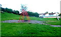
Highfield Play Park, Bassaleg
Access to the play park is from the SW end of Fort View. http://www.geograph.org.uk/photo/3199546
The play park is provided and maintained by Graig Community Council for children of the Graig area.
Image: © Jaggery
Taken: 27 Oct 2012
0.10 miles
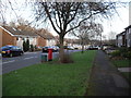
6
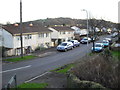
Graig Close, Bassaleg
Houses on the west side of Graig Close, viewed across Laurel Road.
Image: © Jaggery
Taken: 27 Oct 2012
0.10 miles
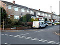
8
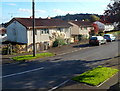
Fort View houses, Bassaleg
Steel-framed houses in Fort View, viewed from the Laurel Road end.
The Fort in question is this one. http://www.geograph.org.uk/photo/619433
Image: © Jaggery
Taken: 27 Oct 2012
0.12 miles
9
Up Highfield Lane, Bassaleg
From the north side of the A468 Caerphilly Road,
Highfield Lane ascends towards Highfield Gardens.
Image: © Jaggery
Taken: 20 Mar 2019
0.13 miles
10
Houses above a bend in Caerphilly Road, Bassaleg
Above the north side of the A468 Caerphilly Road. The double white lines indicate no overtaking.
Image: © Jaggery
Taken: 20 Mar 2019
0.14 miles