IMAGES TAKEN NEAR TO
Pentre-Poeth Road, NEWPORT, NP10 8LL
Introduction
This page details the photographs taken nearby to Pentre-Poeth Road, NP10 8LL by members of the Geograph project.
The Geograph project started in 2005 with the aim of publishing, organising and preserving representative images for every square kilometre of Great Britain, Ireland and the Isle of Man.

There are currently over 7.5m images from over14,400 individuals and you can help contribute to the project by visiting https://www.geograph.org.uk
Image Map
Images are licensed for reuse under creativecommons.org/licenses/by-sa/2.0
Notes
- Clicking on the map will re-center to the selected point.
- The higher the marker number, the further away the image location is from the centre of the postcode.
Image Listing (89 Images Found)
Images are licensed for reuse under creativecommons.org/licenses/by-sa/2.0
Image
Details
Distance
1
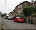
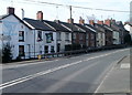
Stone houses at the southern edge of Bassaleg
On the north side of Pentre-Poeth Road.
Image: © Jaggery
Taken: 20 Mar 2019
0.01 miles
3
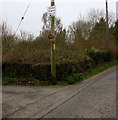
Visibility mirror, Pentre-Poeth Road, Bassaleg
The black arrow on the sign above the mirror points left towards Bethel Baptist Church.
Image: © Jaggery
Taken: 20 Mar 2019
0.03 miles
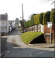
4
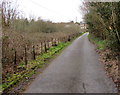
Lane from Bethel Baptist Church to Pentre-Poeth Road, Bassaleg
The northwest side of the church https://www.geograph.org.uk/photo/6096724 is behind the camera.
Image: © Jaggery
Taken: 20 Mar 2019
0.04 miles
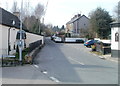
5
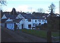
Garth Terrace, Bassaleg
Garth Terrace is a 100-metre long cul-de-sac. Viewed from Caerphilly Road (A468).
Image: © Jaggery
Taken: 5 Mar 2011
0.04 miles
6
Eastern end of Pentre-Poeth Road, Bassaleg
Pentre-Poeth Road heads away from Caerphilly Road, Bassaleg past Cowshed Lane http://www.geograph.org.uk/photo/2771211 on the left and The Ruperra http://www.geograph.org.uk/photo/2771212 on the right.
Image: © Jaggery
Taken: 5 Mar 2011
0.04 miles
7
Get back on the left, bend ahead on Caerphilly Road, Bassaleg
Large white arrows on a black background urge wandering drivers back to the left side of the road. Viewed from opposite the Highfield Lane junction. http://www.geograph.org.uk/photo/2771235
Image: © Jaggery
Taken: 5 Mar 2011
0.05 miles
8
Former Wesleyan Methodist Chapel, Bassaleg
Number 91 Caerphilly Road was formerly a Wesleyan Methodist Chapel built in 1870.
Image: © Jaggery
Taken: 5 Mar 2011
0.05 miles
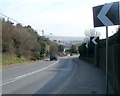
9
Caerphilly Road houses along a 10% incline, Bassaleg
A triangular sign on the left shows a 10% (1 in 10) climb ahead. The Ruperra http://www.geograph.org.uk/photo/2771212 is at the left edge.
Image: © Jaggery
Taken: 5 Mar 2011
0.05 miles
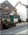
10
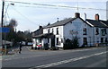
The Ruperra, Bassaleg
Pub with a restaurant located on the corner of Caerphilly Road and Pentre-poeth Road, also known as The Ruperra Arms. The premises date from the 1860s, probably initially a beer house. At the time, any householder who paid rates could apply, for a one-off fee of 2 guineas, to sell beer and cider in their home.
Image: © Jaggery
Taken: 5 Mar 2011
0.05 miles