IMAGES TAKEN NEAR TO
Thorpeville, NORTHAMPTON, NN3 7TR
Introduction
This page details the photographs taken nearby to Thorpeville, NN3 7TR by members of the Geograph project.
The Geograph project started in 2005 with the aim of publishing, organising and preserving representative images for every square kilometre of Great Britain, Ireland and the Isle of Man.

There are currently over 7.5m images from over14,400 individuals and you can help contribute to the project by visiting https://www.geograph.org.uk
Image Map (Loading...)


Getting Data...Please wait
Leaflet Map data © OpenStreetMap
Images are licensed for reuse under creativecommons.org/licenses/by-sa/2.0
Notes
- Clicking on the map will re-center to the selected point.
- The higher the marker number, the further away the image location is from the centre of the postcode.
Image Listing (4 Images Found)
Images are licensed for reuse under creativecommons.org/licenses/by-sa/2.0
Image
Details
Distance
1
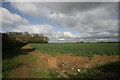
Thorpeville
Overlooking farmland on the edge of Northampton towards Moulton. The spinney on the left is a round spinney called Round Spinney, after which the nearby industrial estate, Round Spinney is named.
Image: © Burgess Von Thunen
Taken: 16 Apr 2010
0.17 miles
2
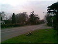
A43
Where Thorpeville becomes Park View. You won't normally see it this quiet.
Image: © Burgess Von Thunen
Taken: 7 Apr 2010
0.17 miles
3
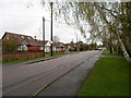
Ashley Lane
Bungalows in Moulton.
Image: © Burgess Von Thunen
Taken: 7 Apr 2014
0.20 miles
4
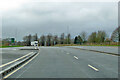
A43 heading south
An unusual layby ahead, one short vehicle in length. What is it for?
Image: © Robin Webster
Taken: 5 Dec 2021
0.25 miles