IMAGES TAKEN NEAR TO
Faringdon Court, NORTHAMPTON, NN3 5JD
Introduction
This page details the photographs taken nearby to Faringdon Court, NN3 5JD by members of the Geograph project.
The Geograph project started in 2005 with the aim of publishing, organising and preserving representative images for every square kilometre of Great Britain, Ireland and the Isle of Man.

There are currently over 7.5m images from over14,400 individuals and you can help contribute to the project by visiting https://www.geograph.org.uk
Image Map
Images are licensed for reuse under creativecommons.org/licenses/by-sa/2.0
Notes
- Clicking on the map will re-center to the selected point.
- The higher the marker number, the further away the image location is from the centre of the postcode.
Image Listing (2 Images Found)
Images are licensed for reuse under creativecommons.org/licenses/by-sa/2.0
Image
Details
Distance
1
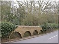
Pondhead Spinney
At this lowest point in the road leading north-west from east Northampton to Moulton, the open brickwork construction would allow any flooding from the large pond behind the spinney to turn the road into a ford.
Image: © Kokai
Taken: 12 Apr 2006
0.05 miles
2
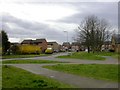
Southfields
A new estate on the north-east edge of Northampton. To the right of the image is seen part of one of the buildings of Southfields Farm. It is now used for business units.
Image: © Kokai
Taken: 12 Apr 2006
0.20 miles