IMAGES TAKEN NEAR TO
Jesslyn Close, Church Way, NORTHAMPTON, NN3 3FB
Introduction
This page details the photographs taken nearby to Jesslyn Close, Church Way, NN3 3FB by members of the Geograph project.
The Geograph project started in 2005 with the aim of publishing, organising and preserving representative images for every square kilometre of Great Britain, Ireland and the Isle of Man.

There are currently over 7.5m images from over14,400 individuals and you can help contribute to the project by visiting https://www.geograph.org.uk
Image Map
Images are licensed for reuse under creativecommons.org/licenses/by-sa/2.0
Notes
- Clicking on the map will re-center to the selected point.
- The higher the marker number, the further away the image location is from the centre of the postcode.
Image Listing (37 Images Found)
Images are licensed for reuse under creativecommons.org/licenses/by-sa/2.0
Image
Details
Distance
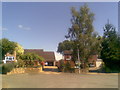
2
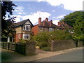
Church Way
1930s semis in Weston Favell.
Image: © Burgess Von Thunen
Taken: 28 May 2010
0.06 miles
3
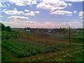
Weston Favell allotments
All locked up and tucked away down Graspin Lane.
Image: © Burgess Von Thunen
Taken: 28 May 2010
0.09 miles
5
Favell Way
1960s houses in Weston Favell.
Image: © Burgess Von Thunen
Taken: 17 Jun 2010
0.10 miles
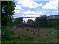
6
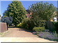
Church Way Close
A private road.
Image: © Burgess Von Thunen
Taken: 17 Jun 2010
0.10 miles
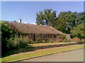
7
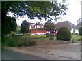
Church Way
Mature bungalows and houses in Weston Favell.
Image: © Burgess Von Thunen
Taken: 27 May 2010
0.12 miles
8
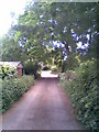
Graspin Lane
With garages for houses on Ridgeway.
Image: © Burgess Von Thunen
Taken: 28 May 2010
0.12 miles
9
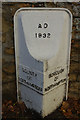
Boundary marker, Weston Favell
This cast iron boundary marker dating from 1932 is located on Church Way just south of St Peter's Church. The borough has expanded considerably since then and the boundary no longer runs here.
Image: © Stephen McKay
Taken: 29 Nov 2018
0.12 miles
10
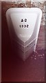
Old Boundary Marker
Municipal Boundary Marker set against a high stone wall on the east side of the junction of Church Way and High Street, Northampton, south of St Peters Church. COUNTY / OF / NORTHAMPTON and BOROUGH / OF / NORTHAMPTON on adjacent faces and A D / 1932 on its head face. See also http://www.geograph.org.uk/photo/5990008.
Milestone Society National ID: NR_NOTON01pb
Image: © S Penhallurick
Taken: 12 Oct 2019
0.12 miles