IMAGES TAKEN NEAR TO
Oak Wood Drive, CORBY, NN18 9BY
Introduction
This page details the photographs taken nearby to Oak Wood Drive, NN18 9BY by members of the Geograph project.
The Geograph project started in 2005 with the aim of publishing, organising and preserving representative images for every square kilometre of Great Britain, Ireland and the Isle of Man.

There are currently over 7.5m images from over14,400 individuals and you can help contribute to the project by visiting https://www.geograph.org.uk
Image Map (Loading...)


Getting Data...Please wait
Leaflet Map data © OpenStreetMap
Images are licensed for reuse under creativecommons.org/licenses/by-sa/2.0
Notes
- Clicking on the map will re-center to the selected point.
- The higher the marker number, the further away the image location is from the centre of the postcode.
Image Listing (14 Images Found)
Images are licensed for reuse under creativecommons.org/licenses/by-sa/2.0
Image
Details
Distance
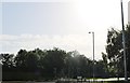
1
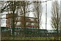
Kingswood upper school
The older secondary school pupils are based at this site.
Image: © Blane Chalmers
Taken: 25 Feb 2007
0.07 miles
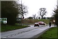
2
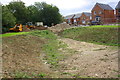
New housing and further development beside Gainsborough Road
This was the site of the Kingswood Grammar School which Ordnance Survey records indicate had a benchmark in 1983 levelled at 121.022m above Newlyn Datum.
Image: © phil Richards
Taken: 12 Sep 2019
0.11 miles
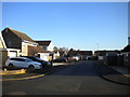
3
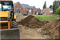
New housing development on site of former Kingswood Grammar School
Image shows another view of the development
Image: © phil Richards
Taken: 12 Sep 2019
0.11 miles
4
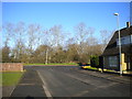
North end of Denmark Close, Danesholme
Approaching Viking Way.
Image: © Richard Vince
Taken: 18 Jan 2020
0.17 miles
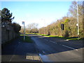
5
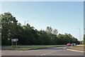
Uppingham Road at the corner of Danesholme Road
Image: © David Howard
Taken: 29 Jun 2019
0.18 miles
6
Junction of Danesholme Road and A6003
Image: © Blane Chalmers
Taken: 25 Feb 2007
0.18 miles
7
North eastern offshoot of Denmark Close, Danesholme
Image: © Richard Vince
Taken: 18 Jan 2020
0.19 miles
8
Danesholme Road at the junction of Gainsborough Road
Image: © David Howard
Taken: 29 Jun 2019
0.19 miles
9
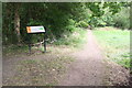
Junction of footpaths at entrance to Kingswood Nature Reserve
Ordnance Survey records indicate that in 1983 there was a rivet benchmark levelled at 119.772m above Newlyn Datum on a rock near this path junction
Image: © phil Richards
Taken: 12 Sep 2019
0.21 miles
10
Viking Way, Danesholme (2)
Passing a small patch of woodland between it and Danesholme Road (left).
Image: © Richard Vince
Taken: 18 Jan 2020
0.21 miles