IMAGES TAKEN NEAR TO
Boughton Close, CORBY, NN18 9AB
Introduction
This page details the photographs taken nearby to Boughton Close, NN18 9AB by members of the Geograph project.
The Geograph project started in 2005 with the aim of publishing, organising and preserving representative images for every square kilometre of Great Britain, Ireland and the Isle of Man.

There are currently over 7.5m images from over14,400 individuals and you can help contribute to the project by visiting https://www.geograph.org.uk
Image Map
Images are licensed for reuse under creativecommons.org/licenses/by-sa/2.0
Notes
- Clicking on the map will re-center to the selected point.
- The higher the marker number, the further away the image location is from the centre of the postcode.
Image Listing (16 Images Found)
Images are licensed for reuse under creativecommons.org/licenses/by-sa/2.0
Image
Details
Distance
1
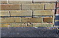
Benchmark on #494 Gainsborough Road
Ordnance Survey cut mark benchmark described on the Bench Mark Database at www.bench-marks.org.uk/bm111631
Image: © phil Richards
Taken: 12 Sep 2019
0.06 miles
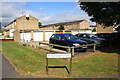
2

Nos.494 and 492 Gainsborough Road
There is an OS benchmark Image on the left hand side of the nearer house, just inside the carport
Image: © phil Richards
Taken: 12 Sep 2019
0.06 miles
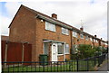
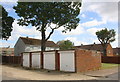
3
Block of garages and houses on Colyers Avenue at Highbrook junction
There used to be a second garage block where the cars are now parked
Image: © Luke Shaw
Taken: 12 Sep 2019
0.15 miles
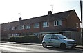
4
Houses on Gainsborough Road at Brighton Road junction
There is an Ordnance Survey cut mark benchmark on the side of the nearest house (#458) at its rear corner: description of the mark at www.bench-marks.org.uk/bm111630
Image: © phil Richards
Taken: 12 Sep 2019
0.16 miles
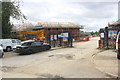
6
Kingswood lower school
The younger secondary school pupils are based on this site.
Image: © Blane Chalmers
Taken: 25 Feb 2007
0.16 miles
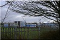
7
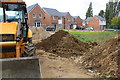
Housing construction site on west side of Tower Hill Road
Ordnance Survey records indicate that in 1983 there was a benchmark levelled at 115.643m above Newlyn Datum on a wall here. This was the site of the Pope John Comprehensive School
Image: © phil Richards
Taken: 12 Sep 2019
0.16 miles
8
Block of 4 garages on NE side of Brighton Road
There is an OS benchmark Image on the right hand side of the block near its front corner
Image: © phil Richards
Taken: 12 Sep 2019
0.19 miles
9
New housing and further development beside Gainsborough Road
This was the site of the Kingswood Grammar School which Ordnance Survey records indicate had a benchmark in 1983 levelled at 121.022m above Newlyn Datum.
Image: © phil Richards
Taken: 12 Sep 2019
0.19 miles
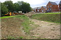
10
New housing development on site of former Kingswood Grammar School
Image shows another view of the development
Image: © phil Richards
Taken: 12 Sep 2019
0.19 miles