IMAGES TAKEN NEAR TO
Farmstead Road, CORBY, NN18 0LL
Introduction
This page details the photographs taken nearby to Farmstead Road, NN18 0LL by members of the Geograph project.
The Geograph project started in 2005 with the aim of publishing, organising and preserving representative images for every square kilometre of Great Britain, Ireland and the Isle of Man.

There are currently over 7.5m images from over14,400 individuals and you can help contribute to the project by visiting https://www.geograph.org.uk
Image Map (20 Images)


Getting Data...Please wait
Leaflet Map data © OpenStreetMap
Images are licensed for reuse under creativecommons.org/licenses/by-sa/2.0
Notes
- Clicking on the map will re-center to the selected point.
- The higher the marker number, the further away the image location is from the centre of the postcode.
Image Listing (20 Images Found)
Images are licensed for reuse under creativecommons.org/licenses/by-sa/2.0
Image
Details
Distance
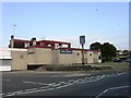
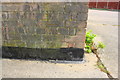
2
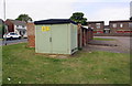
Electricity substation and garage block on east side of Glastonbury Road
Ordnance Survey records indicate that in 1983 there was a benchmark levelled at 124.912m above Newlyn Datum on a 'works' here, possibly on a previous electricity substation. See www.bench-marks.org.uk/bm111864
Image: © Luke Shaw
Taken: 12 Sep 2019
0.04 miles
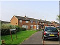
4
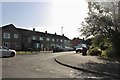
Taunton Avenue at the junction of Beanfield Avenue
Image: © David Howard
Taken: 29 Jun 2019
0.10 miles
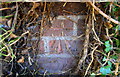
5
Benchmark on garage block of Shoreham Court
Ordnance Survey cut mark benchmark described on the Bench Mark Database at www.bench-marks.org.uk/bm111621
Image: © phil Richards
Taken: 12 Sep 2019
0.12 miles
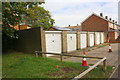
6
Garage block of Shoreham Court, off Selsey Road
There is an OS benchmark Image on the near corner, left hand face, of the block
Image: © phil Richards
Taken: 12 Sep 2019
0.12 miles
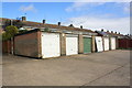
8
Garage block on north side of Selsey Road
Ordnance Survey records indicate that in 1983 there was a benchmark levelled at 120.135m above Newlyn Datum on the front face of the near end wall of the block. This end wall appears to have been rebuilt using different bricks than used elsewhere on the block with the loss of the mark
Image: © phil Richards
Taken: 12 Sep 2019
0.16 miles
9
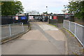
Entrance to Beanfield Primary School from Farmstead Road
Ordnance survey records indicate that in 1983 there was a benchmark levelled at 124.343m above Newlyn Datum on a gatepost at the left hand side of the gateway
Image: © phil Richards
Taken: 12 Sep 2019
0.17 miles
10
Benchmark on gatepost at entrance to St Brendan's Presbytery
Ordnance Survey cut mark benchmark described on the Bench Mark Database at www.bench-marks.org.uk/bm111614
Image: © phil Richards
Taken: 12 Sep 2019
0.18 miles