IMAGES TAKEN NEAR TO
Deene, CORBY, NN17 3EH
Introduction
This page details the photographs taken nearby to NN17 3EH by members of the Geograph project.
The Geograph project started in 2005 with the aim of publishing, organising and preserving representative images for every square kilometre of Great Britain, Ireland and the Isle of Man.

There are currently over 7.5m images from over14,400 individuals and you can help contribute to the project by visiting https://www.geograph.org.uk
Image Map
Images are licensed for reuse under creativecommons.org/licenses/by-sa/2.0
Notes
- Clicking on the map will re-center to the selected point.
- The higher the marker number, the further away the image location is from the centre of the postcode.
Image Listing (12 Images Found)
Images are licensed for reuse under creativecommons.org/licenses/by-sa/2.0
Image
Details
Distance
4
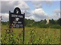
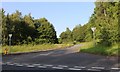
Towards Deene Park
By their sign on the side of the A43.
Image: © David Luther Thomas
Taken: 5 Jul 2007
0.11 miles
5
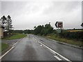
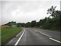
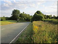
The road to Bulwick
From Stamford Road
Image: © David Howard
Taken: 29 Jun 2019
0.17 miles
7
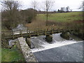
Footbridge over the Willow Brook
Viewed from the top of the weir at Deene Park.
Image: © Michael Trolove
Taken: 23 Jan 2010
0.19 miles
8
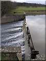
Lake edge and weir at Deene Park
Water pouring over the weir to reform the Willow Brook.
Image: © Michael Trolove
Taken: 23 Jan 2010
0.20 miles
9
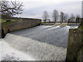
Weir and spillway, Deene Park
Water spilling over the weir to reform the Willow Brook as it meanders down towards Bulwick and then Blatherwycke where another lake forms.
Image: © Michael Trolove
Taken: 23 Jan 2010
0.20 miles
10
The old A43 near Bulwick
Prior to the opening of the Bulwick bypass on 16th April 1986 this was main route linking the principal towns of Northamptonshire with the A1 and the North.
Image: © Jonathan Thacker
Taken: 29 Jul 2019
0.21 miles