IMAGES TAKEN NEAR TO
Biddlesden, BRACKLEY, NN13 5TP
Introduction
This page details the photographs taken nearby to NN13 5TP by members of the Geograph project.
The Geograph project started in 2005 with the aim of publishing, organising and preserving representative images for every square kilometre of Great Britain, Ireland and the Isle of Man.

There are currently over 7.5m images from over14,400 individuals and you can help contribute to the project by visiting https://www.geograph.org.uk
Image Map
Images are licensed for reuse under creativecommons.org/licenses/by-sa/2.0
Notes
- Clicking on the map will re-center to the selected point.
- The higher the marker number, the further away the image location is from the centre of the postcode.
Image Listing (7 Images Found)
Images are licensed for reuse under creativecommons.org/licenses/by-sa/2.0
Image
Details
Distance
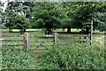
1
View towards Dropshort Farm
Looking across Biddlesden Park.
Image: © Jonathan Thacker
Taken: 29 Nov 2015
0.02 miles
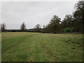
2
Track to Dropshort Farm
Biddlesdon Park.
Image: © Jonathan Thacker
Taken: 29 Nov 2015
0.17 miles
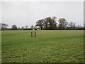
3
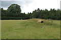
Mound in the Dropshot Farm pasture
Presumably some sort of shelter related to Turweston Airfield across the road
Image: © Philip Jeffrey
Taken: 20 Jun 2020
0.18 miles
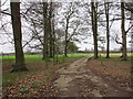
4
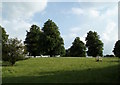
Trees in Biddlesden Park
Taken from the gate in the corner of the field.
Image: © Duncan Lilly
Taken: 12 Jun 2007
0.21 miles
5
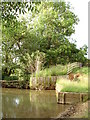
Pond near Dropshort Farm
The land slopes down here to allow the sheep to access to pool. There are two shored tiers on the western side.
"MrsNLewis" has corrected my original entry: This is not a pond but a man-made water splash for horses. There used to be a cross country course at the farm and this was part of it. The sheep do not need a water source as there is a trough in the field. The water splash is served by the stream that runs through it.
Image: © Duncan Lilly
Taken: 12 Jun 2007
0.22 miles