IMAGES TAKEN NEAR TO
Clark Crescent, TOWCESTER, NN12 7AG
Introduction
This page details the photographs taken nearby to Clark Crescent, NN12 7AG by members of the Geograph project.
The Geograph project started in 2005 with the aim of publishing, organising and preserving representative images for every square kilometre of Great Britain, Ireland and the Isle of Man.

There are currently over 7.5m images from over14,400 individuals and you can help contribute to the project by visiting https://www.geograph.org.uk
Image Map
Images are licensed for reuse under creativecommons.org/licenses/by-sa/2.0
Notes
- Clicking on the map will re-center to the selected point.
- The higher the marker number, the further away the image location is from the centre of the postcode.
Image Listing (14 Images Found)
Images are licensed for reuse under creativecommons.org/licenses/by-sa/2.0
Image
Details
Distance
1
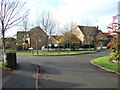
Road junction on The Shires, Towcester
Road junction of Hawthorn Drive and Clark Crescent on The Shires estate in Towcester on land originally part of the former Hesketh Estate. All the roads on this estate are named after famous racing drivers, due to the close proximity of Silverstone motor racing circuit. These two are named after James Clark (1936–1968) and Mike Hawthorn (1929-1959).
Image: © Oliver Hunter
Taken: 15 Nov 2009
0.05 miles
2
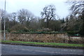
Northampton Road, Towcester
Looking towards Easton Neston grounds
Image: © David Howard
Taken: 28 Dec 2019
0.18 miles
4
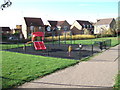
Children's play area on The Shires, Towcester
Looking West across a small children's play area on the North of The Shires housing estate, Towcester. Though on the small side, it is nonetheless popular with the younger inhabitants of the nearby houses.
Image: © Oliver Hunter
Taken: 7 Nov 2009
0.19 miles
5

Abaco on Old Tiffield Road, Towcester
They are a computer and internet company. www.abaco.com
Image: © David Howard
Taken: 20 Mar 2022
0.20 miles
6
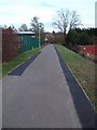
Footpath from Old Tiffield Road to The Shires
Looking down the footpath from the Old Tiffield Road (near Tesco & Homebase) to the South-West end of The Shires housing estate on the land of the Former Hesketh estate, Towcester. The council depot, where dustbin & recycling lorries are housed, is behind the green railings on the left, whilst the container on the right is on the edge of Stable Fabrication Ltd's property.
Image: © Oliver Hunter
Taken: 7 Nov 2009
0.20 miles
7
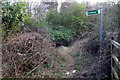
Bridleway off the A43
I can't believe this is used by all that many horses
Image: © Philip Jeffrey
Taken: 21 Apr 2013
0.20 miles
8
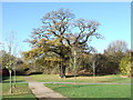
Old Oak Tree, Towcester
One of the listed oak trees on the former hesketh estate, now The Shires housing estate. Taken from the NW corner of Image The A43 dual-carriageway is the other side of the trees in the background.
Image: © Oliver Hunter
Taken: 7 Nov 2009
0.21 miles
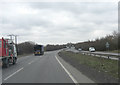
10
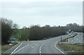
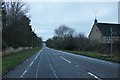
Turn off for Tiffield
A43 heading north east towards the M1 motorway and Northampton.
Image: © JThomas
Taken: 9 Mar 2012
0.21 miles