IMAGES TAKEN NEAR TO
The Paddock, DAVENTRY, NN11 6YF
Introduction
This page details the photographs taken nearby to The Paddock, NN11 6YF by members of the Geograph project.
The Geograph project started in 2005 with the aim of publishing, organising and preserving representative images for every square kilometre of Great Britain, Ireland and the Isle of Man.

There are currently over 7.5m images from over14,400 individuals and you can help contribute to the project by visiting https://www.geograph.org.uk
Image Map (Loading...)


Getting Data...Please wait
Leaflet Map data © OpenStreetMap
Images are licensed for reuse under creativecommons.org/licenses/by-sa/2.0
Notes
- Clicking on the map will re-center to the selected point.
- The higher the marker number, the further away the image location is from the centre of the postcode.
Image Listing (7 Images Found)
Images are licensed for reuse under creativecommons.org/licenses/by-sa/2.0
Image
Details
Distance
1
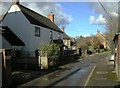
Lower Boddington-Owl End Lane
Cottages on the Lane.
Image: © Ian Rob
Taken: 29 Jan 2010
0.03 miles
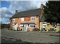
2
The Carpenter's Arms, Lower Boddington.
The pub shown on the OS map and situated on the eastern corner of the crossroads approaching Lower Boddington. There seems to be an apostrophe missing somewhere!
Image: © David Stowell
Taken: 25 Mar 2006
0.08 miles
3
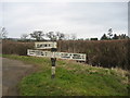
Roadsign at Lower Boddington
Situated on the boundary of the square at the road junction on the west of Lower Boddington. This area has many old finger post road signs such as this, and although they seem to have escaped the attentions of the modernisers they also seem to have lacked the attention of a painter for a while.
Image: © David Stowell
Taken: 25 Mar 2006
0.08 miles
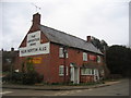
4
Lower Boddington-The Carpenter's Arms
Selling Local Hook Norton Ales
Image: © Ian Rob
Taken: 29 Jan 2010
0.08 miles
5
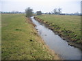
Oxford Canal Feeder
Looking NW along the feeder near Lower Boddington. This channel carries water from Image & Image to the Oxford Canal at Image
Image: © David Stowell
Taken: 25 Mar 2006
0.18 miles
6
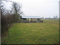
Farm buildings at Lower Boddington
The building marked on the 1:25,000 OS Map just to the west of the lane from Lower Boddington towards Claydon.
Image: © David Stowell
Taken: 25 Mar 2006
0.18 miles
7
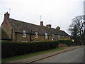
Cottages, Lower Boddington
Built out of the characteristically coloured local stone. These are seen looking west beside the road from Aston le Walls.
Image: © David Stowell
Taken: 25 Mar 2006
0.20 miles