IMAGES TAKEN NEAR TO
Norfolk Avenue, NOTTINGHAM, NG9 6GP
Introduction
This page details the photographs taken nearby to Norfolk Avenue, NG9 6GP by members of the Geograph project.
The Geograph project started in 2005 with the aim of publishing, organising and preserving representative images for every square kilometre of Great Britain, Ireland and the Isle of Man.

There are currently over 7.5m images from over14,400 individuals and you can help contribute to the project by visiting https://www.geograph.org.uk
Image Map (Loading...)


Getting Data...Please wait
Leaflet Map data © OpenStreetMap
Images are licensed for reuse under creativecommons.org/licenses/by-sa/2.0
Notes
- Clicking on the map will re-center to the selected point.
- The higher the marker number, the further away the image location is from the centre of the postcode.
Image Listing (122 Images Found)
Images are licensed for reuse under creativecommons.org/licenses/by-sa/2.0
Image
Details
Distance
1
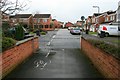
Kindlewood Drive
Taken from the end of a short path / cycleway between it and Norfolk Avenue.
This forms part of a rather tortuous route that Sustrans route 6 takes through the back-ways of Toton to avoid the busy A6005 between Toton Corner and Attenborough.
Image: © David Lally
Taken: 25 Feb 2010
0.05 miles
2
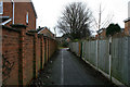
Sustrans Route 6 in Toton
The route follows a quite convoluted path through the new estates in Toton to avoid the busy A6005 between Toton Corner and Attenborough where the main road is quite hostile with pavements quite unsuitable for being shared by pedestrians and cyclists.
Image: © David Lally
Taken: 25 Feb 2010
0.06 miles
3
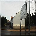
Road sign and white gable
Looking across High Road, Toton.
Image: © David Lally
Taken: 17 Jan 2021
0.07 miles
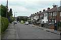
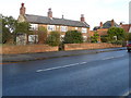
4
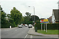
High Road, Toton
The old main road through the village, which is now a large suburban dormitory area.
Image: © Alan Murray-Rust
Taken: 24 Jun 2010
0.08 miles
5
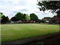
Bowling green in Manor Farm Recreation Ground
Image: © Ian Calderwood
Taken: 31 May 2017
0.10 miles
6
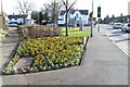
Rutland Road
One of the earliest new roads to be developed as part of the expansion of Toton as a dormitory residential area in the inter-war period.
Image: © Alan Murray-Rust
Taken: 24 Jun 2010
0.11 miles
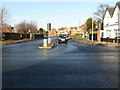
8
Toton Corner
Looking East, High Road, Toton runs from the North to join Nottingham Road. The lights at this junction are well timed with not much hold-ups caused even at peak times.
The Broxtowe Borough workers have been busy recently planting Pansies (not to my taste). This border is sponsored by a Long Eaton based Nursery and child-care company.
The establishment on the corner is The Manor, recently refurbished to be more of a restaurant than a pub.
Image: © David Lally
Taken: 13 Mar 2008
0.12 miles
10

St Peter's Church, Toton
The church was established in the 1920s as part of the parish of Attenborough, a situation that lasted until 2002 when a new parish of Toton was created. The building itself was consecrated in 1954.
Image: © Alan Murray-Rust
Taken: 24 Jun 2010
0.12 miles