IMAGES TAKEN NEAR TO
High Road, NOTTINGHAM, NG9 5DD
Introduction
This page details the photographs taken nearby to High Road, NG9 5DD by members of the Geograph project.
The Geograph project started in 2005 with the aim of publishing, organising and preserving representative images for every square kilometre of Great Britain, Ireland and the Isle of Man.

There are currently over 7.5m images from over14,400 individuals and you can help contribute to the project by visiting https://www.geograph.org.uk
Image Map
Images are licensed for reuse under creativecommons.org/licenses/by-sa/2.0
Notes
- Clicking on the map will re-center to the selected point.
- The higher the marker number, the further away the image location is from the centre of the postcode.
Image Listing (96 Images Found)
Images are licensed for reuse under creativecommons.org/licenses/by-sa/2.0
Image
Details
Distance
1
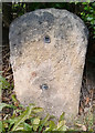
Old Milestone by High Road, Beeston
Stone post (plate lost) by the UC road, in parish of BEESTON (BROXTOWE District), High Road, immediately West of The Close, in hedge, just South of house, on North side of road. Beeston plate, erected by the Nottingham & Grantham, Western End turnpike trust in the 19th century.
Inscription once read:-
(Nottingham)
(5)
(Ashby de la Zouch)
(17)
Milestone Society National ID: NT_NTTM05.
Image: © J Higgins
Taken: 1 Jan 2005
0.01 miles
2
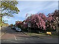
The Close, Chilwell
Cherry blossom at the end of The Close, Chilwell
Image: © Andrew Abbott
Taken: 15 Apr 2020
0.03 miles
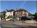
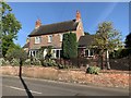
4
Red Lion Cottage
228 High Road, Chilwell
Image: © Andrew Abbott
Taken: 15 Apr 2020
0.05 miles
5
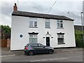
307 High Road, Chilwell
Former offices of Gregory's Roses, commemorated with a blue plaque.
Image: © Andrew Abbott
Taken: 22 May 2020
0.06 miles
7
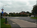
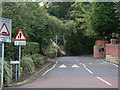
Junction of Bye Pass Road and High Road
High Road is the old main road, replaced in the 1930s by the by pass. The road name signs are spelt Bye Pass, although OS maps show By-pass Road.
Image: © Alan Murray-Rust
Taken: 6 Sep 2009
0.06 miles
8
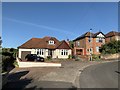
24 Hurts Croft, Chilwell
Bungalow in Chilwell
Image: © Andrew Abbott
Taken: 29 May 2020
0.07 miles
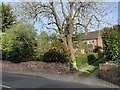
9
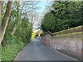
The bottom of Hallam's Lane
The lack of footways indicates that this is an old road.
Image: © Alan Murray-Rust
Taken: 6 Sep 2009
0.08 miles
10
Hallam's Lane Chilwell
Looking north.
Image: © Andrew Abbott
Taken: 17 Apr 2020
0.08 miles