IMAGES TAKEN NEAR TO
Ilkeston Road, NOTTINGHAM, NG9 3PY
Introduction
This page details the photographs taken nearby to Ilkeston Road, NG9 3PY by members of the Geograph project.
The Geograph project started in 2005 with the aim of publishing, organising and preserving representative images for every square kilometre of Great Britain, Ireland and the Isle of Man.

There are currently over 7.5m images from over14,400 individuals and you can help contribute to the project by visiting https://www.geograph.org.uk
Image Map
Images are licensed for reuse under creativecommons.org/licenses/by-sa/2.0
Notes
- Clicking on the map will re-center to the selected point.
- The higher the marker number, the further away the image location is from the centre of the postcode.
Image Listing (56 Images Found)
Images are licensed for reuse under creativecommons.org/licenses/by-sa/2.0
Image
Details
Distance
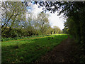
2
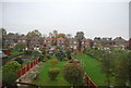
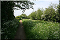
From the footpath on the Nottingham Canal Nature Reserve
Looking south west from the public footpath towards the outskirts of Trowell with Hallam Fields in the far distance. The gardens on Ilkeston Road back up onto the Nature Reserve.
Image: © Kate Jewell
Taken: 12 May 2008
0.07 miles
3
Erewash Valley Line crosses the River Erewash
Image: © Tim Glover
Taken: 28 Jan 1999
0.10 miles
4
Footpath along the Nottingham Canal Nature Reserve
Note how high the canal route is compared to the roofs of the houses on Haynes Avenue, Trowell. This canal follows the 60 metre contour from Wollaton in Image, round Image up to Awsworth in Image, often being quite a height above the adjacent land.
Image: © Kate Jewell
Taken: 12 May 2008
0.10 miles
5
Footpath along the Nottingham Canal
Footpath to the left and bridleway to the right of the filled in Nottingham Canal at Trowell. This ribbon of land is now a Nature Reserve stretching from Wollaton to Langley Mill.
Image: © Kate Jewell
Taken: 12 May 2008
0.10 miles
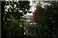
6
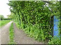
Blue door
Secure entry from path beside old Nottingham Canal
Image: © Chris Morgan
Taken: 12 May 2015
0.11 miles
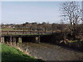
7
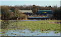
Trowell railway junction, NG9
A railway bridge carrying freight traffic (to the left) over the flooded River Erewash and towards Trowell Junction.
Image: © David Hallam-Jones
Taken: 14 Feb 2013
0.11 miles
8
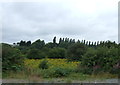
Woodland beside the railway, Trowell Junction
Image: © JThomas
Taken: 17 Aug 2013
0.12 miles
9
Once the Nottingham Canal
The Nottingham Canal was abandoned in the 1930s and this filled-in section is now a nature reserve. Here there are two paths, for walkers and for horses.
Image: © John Sutton
Taken: 14 Oct 2017
0.13 miles
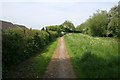
10
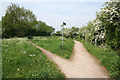
A choice of public right of way
Public footpath to the left and public bridleway to the right. The green area in the middle is the filled in Nottingham Canal. On the OS 1:50,000 map this is shown as still in water but has been filled in for some time. Since 1977, the Broxtowe Borough Council has owned and maintained the upstream sections of the canal from Wollaton to Langley Mill as a nature reserve and walking trail. This part is at Trowell.
Image: © Kate Jewell
Taken: 12 May 2008
0.15 miles