IMAGES TAKEN NEAR TO
Ilkeston Road, NOTTINGHAM, NG9 3JT
Introduction
This page details the photographs taken nearby to Ilkeston Road, NG9 3JT by members of the Geograph project.
The Geograph project started in 2005 with the aim of publishing, organising and preserving representative images for every square kilometre of Great Britain, Ireland and the Isle of Man.

There are currently over 7.5m images from over14,400 individuals and you can help contribute to the project by visiting https://www.geograph.org.uk
Image Map
Images are licensed for reuse under creativecommons.org/licenses/by-sa/2.0
Notes
- Clicking on the map will re-center to the selected point.
- The higher the marker number, the further away the image location is from the centre of the postcode.
Image Listing (68 Images Found)
Images are licensed for reuse under creativecommons.org/licenses/by-sa/2.0
Image
Details
Distance
2
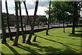
Bramcote Hills Park
A corner of this 27-hectare park, with the junction between Ilkeston Road and Coventry Lane just outside the boundary fence.
Image: © Stephen McKay
Taken: 18 Aug 2012
0.07 miles
4
Bramcote Hills Park
This 27 hectare park is effectively all that divides Stapleford from the west Nottingham suburbs. It is owned by Broxtowe Borough Council.
Image: © Stephen McKay
Taken: 18 Aug 2012
0.08 miles
5
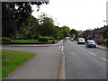
Ewe Lamb Lane
This is a lovely name for an undistinguished suburban road; with Ewe Lamb Close entering from the left.
Image: © Oxymoron
Taken: 10 Aug 2008
0.08 miles
6
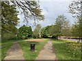
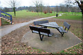
Open space at Oakland Court, Stapleford
Formerly a fish pond.
Image: © Andrew Abbott
Taken: 26 Apr 2020
0.09 miles
7
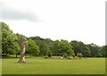
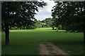
Bramcote Hills Park
Recreating this 'First' for the square https://www.geograph.org.uk/photo/17663 . Not quite the same angle, as I was constrained by the presence of family groups enjoying the park. The two main trees in the original view have now come to the end of their natural lives. The nearer one remains as an upright trunk, but the further one had decayed and by 2007 had been fenced off so that it could be allowed to fall naturally without affecting visitors to the park. This occurred in August 2012, and the fenced area has been allowed to regenerate naturally – degenerate in the case of the fallen tree! This has also been partially sculpted http://www.geograph.org.uk/photo/6928782 .
Image: © Alan Murray-Rust
Taken: 9 Aug 2021
0.09 miles
8
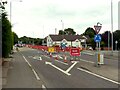
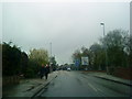
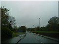
Ilkeston Road closure, Stapleford
A significant closure with substantial diversions while Severn Trent make 'new connections'. The closure notices do not state whether this is for water supply or sewerage.
Image: © Alan Murray-Rust
Taken: 9 Aug 2021
0.09 miles
10
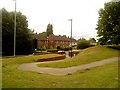
Entrance to Bramcote Hills Country Park
Image: © Andrew Abbott
Taken: 18 Jul 2010
0.09 miles